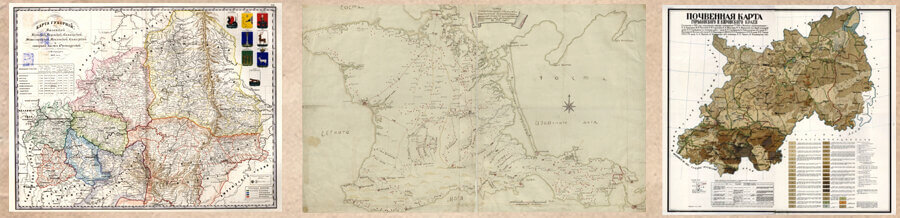

Grishin E. S., Umansky L. A. Methodological foundations of regional historical mapping based on the material of a unified digital model of the European part of the Russian Empire
Posted on 05.05.2022 in Number 1, Volume 1 (2022)
Evgeniy S. Grishin
head of the Scientific Editorial Board of Cartography of the Great Russian Encyclopedia; Institute of
Oriental Studies of the Russian Academy of Sciences; ION RANEPA
Moscow, Russia
E-mail: bibliosof-info@yandex.ru
ORCID: 0000-0002-9521-2246
Leonid A. Umansky
scientific editor of the Great Russian Encyclopedia
Moscow, Russia
E-mail: leonidioum@gmail.com
ORCID: 0000-0002-2528-7402
![]() Download | Back to the Content № 1. 2022
Download | Back to the Content № 1. 2022
УДК 913(470)
DOI: 10.58529/2782-6511-2022-1-1-6-29
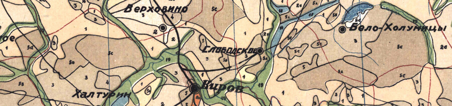
ABSTRACT. The article deals with the issues of constructing a historical map of the regional level. It describes the structure of the map, approaches to its construction. The characteristic of the main cartographic sources that determined the type of regional mapping of the Russian Empire is given. The article contains methodological recommendations and summarizes the experience of making regional historical maps for various purposes. The authors took into account the practice of conducting cartographic work in other disciplines, without ignoring the specifics of historically oriented maps: the problem of dynamics and chronological attribution of objects, the chronological relevance of the map. Studying issues of methodology for mapping individual regions involves solving several separate tasks:
determining the mathematical basis of the map, updating and adapting the general geographical basis, structuring thematic objects of mapping; for each of these tasks, recommendations are given regarding their solution and the implementation of the basic actions of the researchers in the formation of their own cartographic material. A special place in the article is occupied by the structuring of historical
cartographic projects in the format of geographic information systems. Despite the use of the digital model of the Russian Empire as an example, the methodological techniques described in the article are not tied only to a particular region and are formulated with a sufficient level of generalization. The text of the article can be considered as a basis for a more extensive methodological manual on conducting
historical cartographic work.
KEYWORDS: regional mapping, cartographic basis, European part of Russia, province
For citation: Grishin E. S., Umansky L. A. Methodological foundations of regional historical mapping based on the material of a unified digital model of the European part of the Russian Empire // Historical Geography Journal. 2022. Vol. 1. № 1. P. 6–29.
REFERENCES
Grishin E. S. [Fund of Historical-Cartographic Materials as a Means of Unification of Historical GIS and
Digital Cartography]. Istoricheskaya informatika [Historical Information Science], 2019, no. 1, pp. 133–
142. DOI: 10.7256/2585-7797.2019.1.29260 (in Russ.).
Grishin E. S. [Technologies and methods of spatial and temporal analysis application in specially
historical GIS-projects]. Istoricheskaya informatika [Historical Information Science], 2017, no. 2, pp. 74–
84. DOI: 10.7256/2585-7797.2017.2.23295 (in Russ.).
Vladimirov V. N., Rygalova M. V. [Foreign historiography on the problems and prospects of
Geoinformational systems in historical research]. Vestnik Permskogo universiteta. Istoriya [Perm University
Herald. History], 2014, no. 3 (26), pp. 99–106. (in Russ.).
Deduk A. V. Touching upon the history of the Khotetovsky princes’ land ownership (in concern with the question of the location of the centre of Khotetovsky’s inherited land in Karachevsky Principality)
Posted on 02.05.2022 in Number 1, Volume 1 (2022)
Andrew V. Deduk
the head of the archive of the patrimonial and palace establishments of the Russian State Archive of Ancient Acts; Scientific Researcher, State Museum-reserve «Kulikovo field»
Moscow; Tula, Russia
E-mail: deduk@list.ru
ORCID: 0000-0002-9458-3934
![]() Скачать | Back to the Content № 1. 2022
Скачать | Back to the Content № 1. 2022
УДК 913(470):94(470)”14/16”
DOI: 10.58529/2782-6511-2022-1-1-30-51
ABSTRACT. The Upper Oka region is noted for the fact that during 16th–17th centuries it still holds the remains of the land ownership by the descendants of the princes Obolensky, Mosalsky, Vorotynsky, Volkonsky, etc., who used to own lands in the indicated region. One of such family names might be the Khotetovsky family. The representatives of the Khotetovsky clan at least twice left for Moscow: for the first time in 1408 accompanied by Prince Svidrigailo, and for the second time around 1500 with Prince Semyon Belsky. The article analyzes the references to the Khotetovsky clan and their mentioning in the 16th–17th centuries, and reconstructs their genealogy. Different literary sources contain mutually exclusive views concerning the location of the centre of Khotetovsky’s lands. The undertaken study of cadastral and cartographic materials of the 16th–19th centuries enabled the author to find out five toponyms with the root -KHOTET- which might have to do with the centre of the Khotetovsky lands, namely village Yudina, Khotetovskoye of Karachevsky District, Khotetovo, Perkovo of Karachevsky District (after Catherine’s II reformation — Bolkhovsky District), settlement Khotetovo of Orlovsky District (after the administrative reform — Mtsensky District) and hamlet Khotetovsky, village Khotetovo of Aleksinsky District. The article also touches upon the land ownership of the Khotetovsky family in Vorotynsky District. Taking into account the deep analysis of clerical documents of the Domestic Prikaz — Patrimonial board a conclusion is drawn that the only ancestral ownership of the Khotetovsky Princes was settlement Khotetovo which also represents the centre of the Khotetovsky Princes’ lands.
KEYWORDS: Khotetovo, Khotetovsky family, Bolkhov, Karachev principality, localization
For citation: Deduk A. V. Touching upon the history of the Khotetovsky princes’ land ownership (in concern with the question of the location of the centre of Khotetovsky’s inherited land in Karachevsky Principality) // Historical Geography Journal. 2022. Vol. 1. № 1. P. 30–51.
REFERENCES
- Antonov A. V. Rodoslovnye rospisi kontsa XVII veka [Genealogical lists of the late 17th century]. Moscow: Arkheograficheskiy tsentr Publ., 1996. (in Russ.).
- Arkheologicheskaya karta Rossii: Orlovskaya obl. [Archaeological map of Russia: Orel region]. Moscow: b. i., 1992. (in Russ.).
Bentsianov M. M. [“Litvins” and “pans”. The Natives of the Grand Duchy of Lithuania in the Moscow service in the 15th–16th centuries]. Issledovaniya po istorii Vostochnoy Yevropy [Studia Historica Europae Orientalis]. Minsk: b. i., 2019, iss. 12, pp. 86–125. (in Russ.). - Bentsianov M. M. Sluzhilye elity Moskovskogo gosudarstva: formirovanie, status, integratsiya XV–XVI vv. [Service elites of the Moscow State: formation, status, integration. 15–16 centuries]. Moscow: Tsentrpoligraf Publ., 2021. (in Russ.).
- Bespalov R. A. [Lithuanian-Moscow relations of 1392–1408 in connection with the Smolensk, Chernigov and Ryazan policies of Vitovt and Vasily I]. Srednevekovaya Rus [Medieval Rus]. Moskow: Alyans-Arkheo Publ., 2016, iss. 12, pp. 129–182. (in Russ.).
- Bespalov R. A. [The original patrimony of the princes Ogdyrevsky and Mezetsky (according to published sources)]. Gorod Srednevekovya i rannego Novogo vremeni: Arkheologiya. Istoriya [City of the Middle Ages and Early Modern Times: Archeology. History]. Tula: b. i., 2016, iss. 2 (5), pp. 139–161. (in Russ.).
- Bychkova M. E. Sostav klassa feodalov Rossii v XVI v.: istoriko-genealogicheskoe issledovanie [The composition of Russia’s feudal lords class in the 16th century: Historical and genealogical research]. Moscow: Nauka Publ., 1986. (in Russ.).
- Bychkova M. E., Smirnov M. I. Genealogiya v Rossii: Istoriya i perspektivy [Genealogy in Russia: History and Prospects]. Moscow: Territoriya Publ., 2004. (in Russ.).
- Chernov S. Z. [The domain of Moscow princes in city camps: 1271–1505]. Kultura srednevekovoy Moskvy: Istoricheskie landshafty [Culture of Medieval Moscow: historical landscapes]. Moscow: Nauka Publ., 2005, vol. 2, pp. 3–651. (in Russ.).
- Deduk A. V. [From the history of the administrative-territorial division of the Kashirsky and Tula counties in the first half of the 16th century]. Istorik i istochnik: sb. st. k yubileyu Sergeya Nikolaevicha Kistereva [Historian and source: to the anniversary of Sergei Nikolaevich Kisterev]. St. Petersburg: Iskusstvo Rossii Publ., 2018, pp. 219–237. (in Russ.).
- Deduk A. V. [Materials from the patrols of the Aleksinsky district of the 1610s-1620s]. Ocherki feodalnoy Rossii [Sketches of Feudal Russia]. Moscow; St. Petersburg: Alyans-Arkheo Publ., 2020, iss. 21, pp. 300–371. (in Russ.).
- Deduk A. V., Shekov A. V. [Regarding the question of the land ownership of the princes Volkonsky in the first half of the 17th century]. Drevnyaya Rus. Voprosy medievistiki [Old Russia. The questions of Middle Ages], 2021, no. 2, pp. 79–90. (in Russ.).
- Deduk A. V., Shekov A. V. [The 1627/28–1628/29 cadaster of the Aleksin district as a source of historical geography of the Upper Oka Principalities (part 1)]. Gorod Srednevekovya i rannego novogo vremeni — VI: Arkheologiya. Istoriya [City of the Middle Ages and Early Modern Times — VI: Archaeology. History]. Tula: b. i., 2018, pp. 367–467. (in Russ.).
- Florya B. N. [The evolution of tax immunity of Russia’s secular feudal lords in the second half of the 15th — first half of the 16th century]. Istoriya SSSR [History of the USSR], 1972, no. 1, pp. 48–61. (in Russ.).
- Kelembet S. N. [Tarusa principality and its parts]. Srednevekovaya Rus [Medieval Rus]. Moscow: Indrik Publ., 2018, iss. 13, pp. 69–124. (in Russ.).
- Klyuchevskiy V. O. O gosudarstvennosti v Rossii [On statehood in Russia]. Moscow: Mysl Publ., 2003. (in Russ.).
- Kobrin V. B. Vlast i sobstvennost v srednevekovoy Rossii (XV–XVI vv.) [Power and Property in Medieval Russia (15th –16th centuries)]. Moscow: Mysl Publ., 1985. (in Russ.).
- Kuchkin V. A. Formirovanie gosudarstvennoy territorii Severo-Vostochnoy Rusi v X–XIV vv. [The formation of the state territory of North-Eastern Rus’ in the 10th–14th centuries]. Moscow: Nauka Publ., 1984. (in Russ.).
- Kuczyński S. M. Ziemle czernihowski-siewierskie pod rządami Litwy [Ziemle Czernihowski-Siewierskie under the rule of Lithuania]. Warszawa: b. i., 1936. (in Polish).
- Kuzmin A. V. Na puti v Moskvu: ocherki genealogii voenno-sluzhiloy znati Severo-Vostochnoy Rusi v XIII — seredine XV v. [On the way to Moscow: essays on genealogy of military gentry of the North-East Russia in the 13 — mid 15th centuries]. Moscow: Yazyki slavyanskoy kultury Publ., 2014, vol. 1. (in Russ.).
- Massalitina G. A. [Archaeological work at the Opakovskoye settlement]. Velikoe stoyanie na reke Ugre i formirovanie Rossiyskogo tsentralizovannogo gosudarstva: Lokalnye i globalnye konteksty [The Great Stand on the Ugra River and the Formation of the Russian Centralized State: local and global contexts]. Kaluga: Serna Publ., 2017, pp. 221–231. (in Russ.).
- Massalitina G. A. [Medieval Opakov on the Ugra]. Kaluzhskoe nasledie [Kaluga legacy], 2019, no. 1 (5), pp. 58–65. (in Russ.).
- Massalitina G. A., Boldin I. V. [Opakov in Medieval Russian Documents and European Chronicles]. Trudy regionalnogo konkursa nauchnykh proektov v oblasti gumanitarnykh nauk [Proceedings of the regional competition of scientific projects in the field of the humanities]. Kaluga: b. i., 2016, pp. 30–33. (in Russ.).
- Massalitina G. A., Boldin I. V. [Stone defensive tower on the Ugra (archaeological evidence of the Moscow-Lithuanian border conflicts in the upper reaches of the Oka)]. Tver, Tverskaya zemlya i sopredelnye territorii v epokhu Srednevekovya [Tver, Tver land and the adjacent territories in the Middle Ages]. Tver: b. i., 2016, iss. 9, pp. 177–178. (in Russ.).
- Mazurov A. B. Srednevekovaya Kolomna v XIV — pervoy treti XVI vv.: kompleksnoe issledovanie regionalnykh aspektov stanovleniya edinogo Russkogo tsentralizovannogo gosudarstva [Medieval Kolomna in the 14th – first third of the 16th centuries: a comprehensive study of regional aspects of the formation of a single Russian centralized state]. Moscow: Aleksandriya Publ., 2001. (in Russ.).
- Pavlov A. P. [On the patrimonial land ownership of the princes Mosalsky in the 17th century]. Grani russkogo Srednevekovya: sbornik statey k 90-letiyu Yu. G. Alekseeva [The facets of the Russian Middle Ages: a collection of articles dedicated to the 90th anniversary of Yu. G. Alekseev]. Moscow: Drevlekhranilishche Publ., 2016, pp. 78–86. (in Russ.).
- Shekov A. V. Politicheskaya istoriya i geografiya Verkhovskikh knyazhestv: seredina XIII — seredina XVI v. [Political history and geography of the Verkhovsky principalities: mid 13 — mid 14th century]. Moscow: Kvadriga Publ., 2018. (in Russ.).
- Shekov A. V. [Volkona — the city center of the prince inherited land of the late 14–15th centuries]. Gorod srednevekovya i rannego novogo vremeni: Arkheologiya. Istoriya [City of the Middle Ages and Early Modern Times: Archeology. History]. Tula: b. i., 2013, pp. 93–136. (in Russ.).
- Shvatchenko O. A. Svetskie feodalnye votchiny Rossii v pervoy treti XVII v. [Russia’s secular feudal estates in the first third of the 17th century]. Moscow: b. i, 1990. (in Russ.).
- Shvatchenko O. A. Svetskie feodalnye votchiny v Rossii vo vtoroy polovine XVII v. (istoriko-geograficheskiy ocherk) [Secular feudal estates in Russia in the second half of the 17th century (a historical and geographical outline)]. Moscow: b. i., 1996. (in Russ.).
Smolitskaya G. P. Gidronimiya basseyna Oki (spisok rek i ozer) [Hydronymy of the Oka River Basin (the list of rivers and lakes)]. Moscow: Nauka Publ., 1976. (in Russ.). - Stanislavskiy A. L. Trudy po istorii gosudareva dvora v Rossii XVI–XVII vekov [Works on the history of the sovereign’s court in Russia of the 16th–17th centuries]. Moscow: RGGU Publ., 2004. (in Russ.).
- Temushev V. N. [Border war between the Grand Duchy of Moscow and the Grand Duchy of Lithuania in 1487–1494: a map]. Rodina [Motherland], 2003, no. 11, pp. 58–59. (in Russ.).
- Temushev V. N. [Conceptions about the territory and borders of the Upper Oka principalities in the works of researchers]. Verkhnee Podone: Priroda. Arkheologiya. Istoriya [Upper Don region: Nature. Archaeology. History]. Tula: Gosudarstvennyy muzey-zapovednik «Kulikovo pole» Publ., 2007, vol. 2, pp. 257–277. (in Russ.).
- Temushev V. N. Na vostochnoy granitse velikogo knyazhestva Litovskogo [On the eastern border of the Grand Duchy of Lithuania]. Tula: b. i., 2016. (in Russ.).
- Temushev V. N. Territoriya i granitsy Moskovskogo knyazhestva v kontse XIII — pervoy polovine XIV v.: kand. diss. [Territory and borders of Moscow principality at the end of 13th — first half of the 14th centuries: Diss. Cand.]. Minsk, 2002. (in Russ.).
- Vodarskii Ia. E. [Territory and population of the Sevsky razryad in the second half of the 17th — early 18th centuries]. Voprosy istorii khozyaystva i naseleniya Rossii XVII v.: ocherki po istoricheskoy geografii XVII v. [Questions of the history of the economy and population of Russia in the 17th century: essays on the historical geography of the 17th century]. Moscow: b. i., 1974, pp. 215–242. (in Russ.).
- Vodarskii Ia. E. Naselenie Rossii v kontse XVII — nachale XVIII v. (chislennost, soslovno-klassovyy sostav, razmeshchenie) [The population of Russia in the late 17th — early 18th centuries (number, estate-class composition, location)]. Moscow: b. i., 1977. (in Russ.).
- Vorotneykova I. A., Nedelin V. M. Kremli, kreposti i ukreplennye monastyri Russkogo gosudarstva XV–XVII vv. [Kremlins, fortresses and fortified monasteries of the Russian state of the 15th–17th centuries]. Moscow: Indrik Publ., 2016, vol. 2, book 1. (in Russ.).
- Yerusalimskiy K. [Brothers and comrades-in-arms: the family saga of the Bunaks in exile]. Sbornik statey pamyati Yu. D. Rykova [Collection of articles in memory of Yu. D. Rykov]. (in print). (in Russ.).
- Yerusalimskiy K. Na sluzhbe korolya i Rechi Pospolitoy [At the service of the King and the Polish–Lithuanian Commonwealth]. Moscow; St. Petersburg: Nestor-istoriya Publ., 2018. (in Russ.).
- Yushko A. A. Feodalnoe zemlevladenie Moskovskoy Rusi XIV v. [Feudal land ownership in Moscow principality]. Mosсow: Nauka Publ., 2002. (in Russ.).
- Zimin A. A. Formirovanie boyarskoy aristokratii v Rossii vo vtoroy polovine XV — pervoy treti XVI v. [Formation of Boyar aristocracy in the second half of 15 — first third 16th centuries]. Moscow: Nauka Publ., 1988. (in Russ.).
Sanzharov V. A., Bakanova E. N. Royal Itinerary of Philip VI of Valois: the Phenomenon of «Nomadism» of Power Institutions in the Middle Ages
Posted on 01.05.2022 in Number 1, Volume 1 (2022)
Valery A. Sanzharov
Candidate of Historical Sciences, free researcher
Gorlovka
E-mail: valsandzh@yandex.ru
ORCID: 0000-0003-4075-8572
Elena N. Bakanova
Undergraduate of the Faculty of History, Donetsk National University
Donetsk
E-mail: elena.bakanova0@gmail.com
ORCID: 0000-0002-3029-7381
![]() Download | Back to the Content № 1. 2022
Download | Back to the Content № 1. 2022
УДК 94(44)”653”
DOI: 10.58529/2782-6511-2022-1-1-52-63
ABSTRACT. The article is devoted to the royal itinerary of Philip VI Valois (1328–1350). The royal itinerary is not a simple calendar list of visited places but a source characterizing the implementation of the government strategies — ‘the style of governing’. It addresses various aspects of the problems of power, the mechanisms of its implementation, the formation and realization of managerial and representative strategies, the personal and institutional factors, the definition of spaces of real power. The article analyzes the notions of the capital on the basis of the royal itinerary; the seasonal nature of the journeys of the king and his court; logistics of royal trips; the influence of church holidays on the places of stay and travel routes of the royal court; space of power and space of residence; royal residences and hunting grounds. The geographical activity of Philip VI, despite all its intensity, is a pronounced monocentric model with division into separate sites (zones) based on the frequency and repeatability of visits. The authors concluded that the various royal residences in the Ile-de-France form a kind of unity, a spatial continuum located along the Oise and Seine rivers from Compiegne to Fontainebleau. During the reign of Philip VI, Ile-de-France was the only living space of the French king. Paris was its geographical center. The residences of the royal court are within one day’s journey from Paris. The pair residences Paris-Vincennes and Paris–Saint-Germain-en-Laye stand out as the main management centers.
KEYWORDS: Valois, Philip VI, itinerary, Hundred Years War, Electronic Database, geographic information systems
For citation: Sanzharov V. A., Bakanova E. N. Royal Itinerary of Philip VI of Valois: the Phenomenon of “Nomadism” of Power Institutions in the Middle Ages // Historical Geography Journal. 2022. Vol. 1. № 1. P. 52–63.
REFERENCES
- Bautier R.-H. Recherches sur la chancellerie royale au temps de Philippe VI. Bibliothèque de l’école des chartes, 1964, T. 122, pp. 89–17; 1965, Т. 123 (2), pp. 313–459. (in French).
- Bove B. Alliance ou défiance? Les ambiguïtés de la politique des Capétiens envers leur capitale entre le XIIe et le XVIIe siècle. Les villes capitales au Moyen Âge. Paris: Publications de la Sorbonne, 2006, pp. 131–154. (in French).
- Bove B. Les palais royaux à Paris au Moyen Âge (xie-xve siècles). Palais et pouvoir, de Constantinople à Versailles. Saint-Denis: Presses universitaires de Vincennes, 2003, pp. 45–79. (in French).
- Bove B. Les rois médiévaux sont-ils Parisiens ? Essai de synthèse des itinéraires royaux médiévaux de Philippe Auguste à Louis XI (1180–1483). Paris ville de cour (XIIIe–XVIIIe siècle). Rennes, 2017, pp. 25–49. (in French).
- Bove B. Saint-Germain-en-Laye: forteresse sur la route de la Normandie ou résidence ‘comme au milieu de France’? Saint-Germain, ville militaire. Bulletin des Amis du Vieux Saint-Germain, 2018, no. 55, pp. 17–33. (in French).
- Bove B., Gaude-Ferragu M., Michon C. (dir.) Paris, ville de cour (XIIIe-XVIIIe siècle). Rennes: Presses Universitaires de Rennes, 2017. (in French).
- Bove B., Jacqueton A. Itinéraire de Philippe VI. Les lieux de séjour du roi d’après ses actes et ses comptes (1328–1350). Paris, Cour de France.fr, 2016. Available at: http://cour-de-france.fr/article4325.html (accessed: 20.12.2019). (in French).
- Bove B., Salamagne A., zum Kolk C. (dir.) L’itinérance de la cour en France et en Europe (Moyen Âge–XIXe siècle). Villeneuve d’Ascq: Presses universitaires du Septentrion, 2021. (in French).
- Brown E. A. R., Regalado N. F. La Grant Feste. The Account of the 1313 Celebration of the Knighting of the Three Sons of Philip the Fair in the Chronique métrique in BN MS Fr. 146. City and Spectacle in Medieval Europe. Minneapolis: University of Minnesota press, 1994, pp. 56–86. (in English).
- Brown E. A. R., Regalado N. F. Universitas et Communitas: The Parade of the Parisians at the Pentecost Feast of 1313. Moving Objects: Processional Performance in the Middle Ages and the Renaissance. Amsterdam: Rodopi, 2001, pp. 117–154 (in English).
- Cazelles R. (éd.) Philip VI. Lettres closes, lettres “de par le roi” de Philippe de Valois. Annuaire-Bulletin de la Société de l’histoire de France. Années 1956–57, 1958, pp. 61–225. (in French).
- Cazelles R. Paris de la fin du règne de Philippe Auguste à la mort de Charles V, 1223–1380. Paris: Hachette, 1972. (in French).
- Chevalier B. Le paysage urbain à la fin du Moyen Âge : Imagination et réalités. Le paysage urbain au Moyen Age. Actes du xie congrès des historiens médiévistes de l’Enseignement Supérieur. Lyon: Presses Universitaires de Lyon, 1981, pp. 7–21. (in French).
- Filippova E. B., Bakanova E. N. [Itinerary of the first representative of the Valois dynasty (creation and possibilities of using the database)]. Mir Evrazii: ot drevnosti k sovremennosti [The World of Eurasia: from Antiquity to the Present]. Ufa: RIC BashGU Publ., 2021, vol. 1, pp.123–128. (in Russ.).
- Gasnault P. (éd.) Philip VI. Nouvelles lettres closes et “de par le roi” de Philippe VI de Valois. Bibliothèque de l’école des chartes, 1962, vol. 120, pp. 172–178. (in French).
- Grishin E. S. [Spatial mobility of Henry IV in 1063–1073 as a factual basis for analyzing the dissemination of information in medieval Germany]. Istoricheskaya informatika [Historical Information Science], 2018, no. 3, pp. 106–122. (in Russ.).
- Grishin E. S., Sanzharov V. A. [Royal Itineraries as a Historical Source: on the Example of the Permanent Residences and Travel Routes of Louis XI (1461–1483)]. Istochnikovedenie v sovremennoj medievistike [Source studies in modern medieval studies]. Moscow: IVI RAN Publ., 2020, pp. 322–325. (in Russ.).
- Guenée B., Lehoux F. Les Entrées royales françaises de 1328 à 1515. Paris: Éditions du CNRS, 1968. (in French).
- Guerout J. Le Palais de la Cité à Paris des origines à 1417: essai topographique et archéologique. Paris et Ile-de-France: Mémoires de la Fédération des Sociétés Historiques et Archéologiques de Paris et de l’Ile-de-France, 1949, vol. 1, рр. 57–212; 1950, vol. 2, рр. 21–204; 1951, vol. 3, рр. 7–101. (in French).
- Guyot-Bachy I. La géographie urbaine des chroniqueurs parisiens de Philippe le Bel à l’avènement de Charles V. Être parisien. Paris: Éditions de la Sorbonne, 2004, pp. 481–492. (in French).
- Lalou E. Itinéraire de Philippe IV le Bel (1285–1314). Paris: Mémoires de l’Académie, 2007, vol. 2. (in French).
- Miret y Sans J. Lettres closes des premiers Valois. Moyen Âge, 1917–1918, vol. 10, pp. 53–88. (in French).
- Sanzharov V. A., Smagin M. R., Filippova E. B. [Possibilities of statistical processing of formalized data based on the itinerary of Louis XI (1461–1483)]. Mir Evrazii: ot drevnosti k sovremennosti [The World of Eurasia: from Antiquity to the Present]. Ufa: RIC BashGU Publ., 2020, vol. 1, pp. 141–146. (in Russ.).
- Tsaturova S. K. Formirovanie instituta gosudarstvennoj sluzhby vo Francii XIII–XV vekov [Formation of the institution of civil service in France of the 13–15th centuries]. Moscow: Nauka Publ., 2012. (in Russ.).
- Vallee A. (éd.) Registres du Trésor des Chartes: Inventaire analytique. Paris: Archives Nationales, 1978–1979, T. 3: Règne de Philippe de Valois. (in French).
- Viard J. (éd.) Grandes chroniques de France. Paris: H. Champion, 1937, Т. 9: Charles IV le Bel, Philippe VI de Valois. (in French).
- Viard J. Itinéraire de Philippe VI de Valois. Bibliothèque de l’école des chartes, 1913, vol. 74, pp. 74–128, 525-619; 1923, vol. 84, pp. 166–170. (in French).
- Viard J. Philippe VI de Valois. Début du règne (février–juillet 1328). Bibliothèque de l’école des chartes, 1934, vol. 95, pp. 259–283. (in French).
Razinkov S. L. Analysis of the development of a vocational educational institutions network in the Sverdlovsk region in the 1920s–1950s by means of using database technology and GIS
Posted on 30.04.2022 in Number 1, Volume 1 (2022)
Sergey L. Razinkov
Candidate of Historical Sciences, Russian State Vocational Pedagogical University
Ekaterinburg, Russia
E-mail: sergerazinkov@mail.ru
ORCID: 0000-0002-0018-7931
![]() Скачать | Back to the Content № 1. 2022
Скачать | Back to the Content № 1. 2022
УДК 94(470.5)”1920/1950”
DOI: 10.58529/2782-6511-2022-1-1-64-81
ABSTRACT. The paper analyzes the change in the composition, quantity and territorial deployment of vocational educational institutions in the Sverdlovsk region (within its present-day borders) in the 1920s–1950s. Based on the use of database technology and geographic information systems, it attempts to identify and localize educational institutions, to detect the stages of development and trends in changes of their network. The evolution of the regional network of vocational educational institutions is analyzed mainly in five time points: 1) 1922–1923 — the beginning of the formation of the Soviet model of vocational education; 2) 1932–1933 — an intensive expansion of the departmental network of vocational education institutions during; 3) 1940 – early 1941 — the creation of a system of State labor reserves as a single nationwide system for the training of qualified workers; 4) 1948 — the functioning of the network of educational institutions at the maximum level of quantitative indicators as a result of its extensive development; 5) 1958 — reforming the system of vocational education in order to differentiate and deepen the level of training of workers. The study of a vocational educational institutions network, concentrated in 20 sub-regions of the Sverdlovsk region, revealed a number of trends associated with a constant quantitative growth in the number of educational institutions and the contingent of students; consolidation of educational institutions and their relocation from the «old» industrial centers to areas of concentration of industrial enterprises built during the first five-year plans or evacuated during the Great Patriotic War.
KEYWORDS: vocational and technical education, State labor reserves, network of educational institutions, Sverdlovsk region, vocational schools, FZU schools, FZO schools
For citation: Razinkov S. L. Analysis of the development of a vocational educational institutions network
in the Sverdlovsk region in the 1920s–1950s by means of using database technology and GIS // Historical Geography Journal. 2022. Vol. 1. № 1. P. 64–81.
REFERENCES
- Bystritskiy M. G., Serebrennikov G. N. Novaya bronya podrostkov [New reservation for adolescents]. Moscow: b. i., 1929. (in Russ.).
- Ignatev V. A. [Essays on the history of vocational education at the Verkh-Isetsky metallurgical plant in Soviet times]. Professionalno-tekhnicheskoe i professionalno-pedagogicheskoe obrazovanie v regionalnom razreze: Sverdlovskaya oblast [Vocational and vocational pedagogical education in the regional context: Sverdlovsk region]. Ekaterinburg: RGPPU Publ., 2020, pp. 877–918. (in Russ.).
- Milostnaya L. I. [The activities of the Ural party organizations for the development of vocational education in 1928–1932]. Deyatelnost partiynykh organizatsiy Urala i Zapadnoy Sibiri po razvitiyu narodnogo obrazovaniya i kultury [Activities of party organizations of the Urals and Western Siberia for the development of public education and culture]. Sverdlovsk: SGPI Publ., 1978, pp. 21–34. (in Russ.).
- Poberezhnikov I. V. [Spatial aspects of Russian modernizations]. Ekonomicheskaya istoriya [Economic history], 2010, no 2, pp. 18–26. (in Russ.).
- Postnikov S. P., Feldman M. A. Gosudarstvo i professionalnaya podgotovka rabochikh kadrov promyshlennosti Urala v 1900–1940 gg. [The state and professional training of workers in the industry of the Urals in 1900–1940]. Ekaterinburg: UrO RAN Publ., 2004. (in Russ.).
- Razinkov S. L., Zakharovsky L. V. [Vocational education in the Sverdlovsk region (1920–1950s)]. Database. 2020. Available at: https://elibrary.ru/item.asp?id=40879797 (accessed: 01.12.2021). (in Russ.).
- Serdyukov A. A. Pedagogicheskie kadry professionalno-tekhnicheskoy shkoly Rossii. 1959–1985 gg. [Teaching staff of the vocational school in Russia. 1959–1985]. Ekaterinburg: URGPI Publ., 2001. (in Russ.).