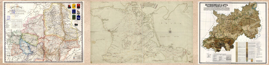

Kaisin А. О. Pantyukhina К. А. General Map of the Vyatka Province with Plans and Views of the Provincial Town, Uezd and Uezd-Less Towns of 1806
Posted on 24.09.2024 in Number 2, Volume 3 (2024)
Alexey O. Kaisin
Vyatka State University
Kirov, Russia
E-mail: akai_slob@mail.ru
ORCID: 0000-0002-6188-0043
Ksenia А. Pantyukhina
Vyatka State University
Kirov, Russia
E-mail: kseniapantyuhina@gmail.com
ORCID: 0009-0000-3218-4463
![]() Download | Back to the Content № 2. 2024
Download | Back to the Content № 2. 2024
UDC 94(470.342) “18”:913.1
DOI: 10.58529/2782-6511-2024-3-2-122-133
ABSTRACT. Publication of the General Map of the Vyatka province introduces a unique cartographic source on the history of Russian urban planning into scientific circulation. The peculiarity of the map is that, in addition to having a general map of the province and plans of its thirteen towns, there are drawn general views of the towns. Most of the views represent the first illustrative images of the towns of the Vyatka province. The general map was compiled by the provincial surveyor, collegiate assessor Evstafy Rodionov in 1806 The scientific value of his work lies in particular in the fact that the images of Vyatka towns on the General Map are imprinted at the time of their restructuring began at the end of the 18th century. At the same time, town plans show both the parts planned for development in the future and the districts built up in the 17th — first half of the 18th centuries. The map shows the views of the provincial, 9 uezd and 3 uezd-less (supernumerary) towns of the Vyatka province.
KEYWORDS: historical geography, cartographic sources, 19th century, Vyatka province, planning, urban planning, general map
For citation: Kaisin A. O., Pantyukhina K. A. [General Map of the Vyatka Province with Plans and Views of the Provincial Town, Uezd and Uezd-Less Towns of 1806]. Istoriko geograficheskiy zhurnal [Historical Geography Journal], 2024, vol. 3, no. 2, pp. 122–133. DOI: 10.58529/2782-6511-2024-3-2-122-133 (In Russian).
Received 5 March 2024
Accepted 3 June 2024
© 2024 The Autors
REFERENCES
-
Andreeva E. A. [The History of Town-Planning in Vyatka Province (End of ХVIII — Beginning of ХХ Centuries)]. Lokus: lyudi, obshchestvo, kul’tury, smysly [Locus: People, Society, Cultures, Meaning], 2013, no. 4, pp. 5–16. (In Russian).
-
Andreeva E. A. [The History of Development of Sarapul as a Typical Russian County Town at the End of 19th — Beginning of the 20th Century]. Lokus: lyudi, obshchestvo, kul’tury, smysly [Locus: People, Society, Cultures, Meaning], 2018, no. 2, pp. 11–20. (In Russian).
-
Bezverkhova L. B. Arkhitekturnyye etyudy [Architectural Sketches]. Kirov: Bukvitsa Publ., 2017 (In Russian).
-
Deduk A. V., Glazyrina M. K., Kaisin A. O. [Topographical Description of the Vyatka Viceroyalty. 1784–1785]. Istoricheskiy arkhiv [Historical Archives], 2024, no. 3, pp. 169–201. (In Russian).
-
Kaysin A. O., Glazyrina M. K., Deduk A. V. [Topographic Description of the Vyatka Viceroyalty of 1784–1785]. Istoricheskiy arkhiv [Historical Archives], 2024, no. 2, pp. 150–188. (In Russian).
-
Khudyakov M. G. Istoriya Kamsko-Vyatskogo kraya: Izbrannyye trudy [History of the Kama-Vyatka Region: Selected Works]. Izhevsk: Udmurtiya Publ., 2008 (In Russian).
-
Kurochkin M. V. Sarapul’skiy klassitsizm. Arkhitektura Prikam’ya [Sarapul Classicism. Architecture of the Kama Region]. Izhevsk: Izdatel’skiy tsentr “Udmurtskiy universitet” Publ., 2017 (In Russian).
-
Pentina N. B. [How the City of Urzhum Was Built]. Gertsenka: Vyatskiye zapiski [Herzenka: Vyatka Notes]. Kirov: S. n., 2007, iss. 11, pp. 149–168. (In Russian).
-
Razrushennyye khramovyye postroyki Kirovskoy oblasti: materialy istoriko-arkhivnykh i bibliograficheskikh issledovaniy: spravochnik [Destroyed Temple Buildings of the Kirov Region: Materials of Historical, Archival and Bibliographic Research: Reference Book]. Kirov: “Raduga-PRESS” Publ., 2012, part 1 (In Russian).
-
Tinsky A. G. Planirovka i zastroyka goroda Vyatki v XVII–XIX vekakh [Planning and Development of the City of Vyatka in the 17th–19th Centuries]. Kirov: Volgo-Vyatskoye kn. izd-vo Publ., 1976 (In Russian).
Ignatova N. М. Dislocation Distances of Labor Settlements Positions in the Komi ASSR, Arkhangelsk and Vologda Regions in 1941
Posted on in Number 2, Volume 3 (2024)
Nadezhda M. Ignatova
Candidate of Historical Sciences, Institute of Language, Literature and History of the FRC Komi Science Centre, Ural Branch of the Russian Academy of Sciences
Syktyvkar, Russia
E-mail: ignatova11@rambler.ru
ORCID: 0000-0002-1075-9382
![]() Download | Back to the Content № 2. 2024
Download | Back to the Content № 2. 2024
UDC 94(470.1) “1941/1942”
DOI: 10.58529/2782-6511-2024-3-2-134-147
ABSTRACT. The article analyzes data on the location of labor settlements based on dislocation tables. The dislocation tables belong to the departmental reporting documentation of the NKVD of the USSR. The information reflects the situation for the second half of 1941, since data for the Arkhangelsk and Vologda regions are given as of November 1941, and for the Komi ASSR as of January 1, 1942 The requirements for the position of labor settlements and the features of their organization are considered. A calculation of the average distances from labor settlements to the railway track, the district commandant’s office and the regions’ administrative center is given. Analyzing the distances from labor settlements to transport routes, district and administrative centers allows assessing remoteness of settlements from railway transport and populated areas. The Komi ASSR, Arkhangelsk and Vologda regions in 1929–1936 were administratively united as part of the Northern Krai, so the organization in the early 1930s of settlements for special settlers – “former kulaks,” renamed in labor settlements in 1933, proceeded according to general plans, so it seems relevant to assess the situation for the three regions as a whole.
KEYWORDS: special settlements, labor settlements, special settlers — “former kulaks”, labor settlers, dislocation, North
For citation: Ignatova N. M. [Dislocation Distances of Labor Settlements Positions in the Komi ASSR, Arkhangelsk and Vologda Regions in 1941]. Istoriko-geograficheskiy zhurnal [Historical Geography Journal], 2024, vol. 3, no. 2, pp. 134–147. DOI: 10.58529/2782-6511-2024-3-2-134-147 (In Russian).
Received 8 April 2024
Accepted 20 May 2024
© 2024 The Autor
REFERENCES
-
Ivanov A. S., Mikhalev N. A. Spetspereselentsy na Zapadno-Sibirskom Severe v gody Velikoy Otechestvennoy voyny (1941–1945) [Special settlers in the West Siberian North during the Great Patriotic War (1941–1945)]. Moscow: ROSSPEN Publ., 2023 (In Russian).
-
Ivnitsky N. A. Kollektivizatsiya i raskulachivaniye (nachalo 30-kh godov) [Collectivization and Dekulakization (Early 30s)]. Moscow: Interpraks Publ., 1994 (In Russian).
-
Kozhevnikov S. A. [Challenges and Prospects of Transport Development Infrastructure of the Regions of the European North Russia]. Nauchnyy vestnik Yuzhnogo instituta menedzhmenta [Scientific Bulletin of the Southern Institute of Management], 2018, no. 4, pp. 19–26. DOI: 10.31775/2305-3100-2018-4-19-26 (In Russian).
-
Kuratova E. S. [Methodology for Assessing the Transport Security of the Territory for the Availability of Social Services]. Ekonomicheskie i sotsial’nye peremeny: fakty, tendentsii, prognoz [Economic and Social Changes: Facts, Trends, Forecast], 2014, no. 5 (35), pp. 251–259. DOI: 10.15838/esc/2014.5.35.21 (In Russian).
-
Yankov K. V. [Transport Accessibility Issue of Settlements in Federal Strategic Planning Documents]. Problemy razvitiya territorii [Problems of Territory’s Development], 2021, vol. 25, no. 6, pp. 118–130. DOI: 10.15838/ptd.2021.6.116.7 (In Russian).
Shumkin G. N. Documents on the Preparation for Alexander I’s Trip to the Urals in 1824 (To the 200th Anniversary of the Event)
Posted on 11.05.2024 in Number 1, Volume 3 (2024)
Georgy N. Shumkin
Candidate of Historical Sciences, Institute of History and Archaeology, Ural Branch of the Russian Academy of Sciences
Ekaterinburg, Russia
E-mail: shumk@mail.ru
ORCID: 0000-0003-1858-8001
![]() Download | Back to the Content № 1. 2024
Download | Back to the Content № 1. 2024
UDC 930.2(47)“1824”:910.4
DOI: 10.58529/2782-6511-2024-3-1-86-97
ABSTRACT. The publication of the documents is dedicated to the 200th anniversary of Emperor Alexander I’s trip to the Urals in 1824 The Emperor’s interest in this region was not accidental. During the reign of Alexander I, a number of reforms were carried out, during which a system of mining law was created («Draft of Mining Regulations»), the system of state-owned mining districts was institutionalized, a class of indispensable workers was created, and intensive gold mining began. These measures prepared the conditions for the transformation of the Urals into a special region — the Ural Mining Oblast. The publication includes copies of documents from the correspondence of the Zlatoust and Ekaterinburg mining chiefs, deposited in the fund of the Department of Mining and Salt Affairs of the Ministry of Finance of the Russian State Historical Archive. The published materials are devoted to the preparation of the Orenburg province for the meeting of the emperor. The publication of the documents is preceded by an introductory article.
KEYWORDS: Alexander I, Urals, trip, mining industry, administration.
For citation: Shumkin G. N. Documents on the Preparation for Alexander I’s Trip to the Urals in 1824 (To the 200th Anniversary of the Event) // Historical Geography Journal. 2024 Vol. 3 № 1 P. 86–97.
REFERENCES
-
Imperator Aleksandr I na Urale [Emperor Alexander I in the Urals]. Chelyabinsk: Avtograf Publ., 2022 (In Russian).
-
Novikov I. A. [Alexander I in Zlatoust]. Makhovik [Flywheel], 1991, no. 5, pp. 66–72. (In Russian).
-
Novikov I. A. [Alexander I and the Reform of the Management System of Mining Factories in the Urals]. Problemy sotsial’no-politicheskoy i etnicheskoy istorii Rossii XIV–XX vv. [Problems of Socio-Political and Ethnic History of Russia in the 14th–20th Centuries]. Chelyabinsk: Chelyabinskiy gos. un-t Publ., 1995, pp. 27–40. (In Russian).
-
Okuntsov Yu. P. Zlatoustovskaya oruzheynaya fabrika [Zlatoust Weapons Factory]. Moscow: Veche Publ., 2011 (In Russian).
-
Smilyanets K. V., Ustinov A. L. [Alexander I in the Urals. Events and Consequences]. Aktual’nyye voprosy sovremennoy meditsinskoy nauki i zdravookhraneniya [Current Issues of Modern Medical Science and Healthcare]. Ekaterinburg: Ural’skiy gos. med. un-t Publ., 2019, vol. 3, pp. 297–302. (In Russian).
Kholmatov T. K. «In Institute for History and Archives Historical Geography Hasn’t Disappeared Yet»: The Letters of O. М. Medushevskaya to V.K. Yatsunskiy (1956–1966)
Posted on in Number 1, Volume 3 (2024)
Temurmalik K. Kholmatov
Candidate of Historical Sciences, National Research University «Higher School of Economics»
Moscow, Russia
E-mail: timur.kholmatoff@yandex.ru
ORCID: 0000-0002-2975-1647
![]() Download | Back to the Content № 1. 2024
Download | Back to the Content № 1. 2024
UDC 930.2(47)“1956/1966”
DOI: 10.58529/2782-6511-2024-3-1-98-107
ABSTRACT. The publication includes the letters by O. M. Medushevskaya to V. K. Yatsunskiy written in 1956–1966. They are of interest to the study of the beginning of O. М. Medushevskaya’s research path, which is associated with historical geography and the history of geographical knowledge. The letters’ main themes are — the work of O. M. Medushevskaya at the Department of Auxiliary Historical Disciplines of the Moscow State Institute for History and Archives, preparation for publication of the lectures on the 17th—19th centuries maps, consultation of E. G. Istomina (Gelman) on the topic of the candidate dissertation (about the historical geography of the Novgorod province in the 18th century). These published sources are of particular interest for studying intergenerational communication between V. K. Yatsunskiy and O. M. Medushevskaya, the relationship between the teacher and the student. The letters were found in the personal fund of V. K. Yatsunskiy in the Archive of the Russian Academy of Sciences.
KEYWORDS: O. М. Medushevskaya, V. K. Yatsunskiy, E. G. Istomina, historical geography, Soviet historical science, letters, Archive of the Russian Academy of Sciences.
For citation: Kholmatov T. K. «In Institute for History and Archives Historical Geography Hasn’t Disappeared Yet»: The Letters of O. М. Medushevskaya to V.K. Yatsunskiy (1956–1966) // Historical Geography Journal. 2024 Vol. 3 № 1 P. 86–97.
REFERENCES
-
Alevras N. N. [The Theory of Source and the Image of Source Studies in the Concept of Cognitive History by Olga M. Medushevskaya]. Dialog so vremenem [Dialogue with Time], 2013, no. 44, pp. 79–88. (In Russian).
-
Ananiev V. G. [The Letters of O. M. Medushevskaya to A. I. Andreev (On the Materials of Saint-Petersburg Branch of the Institution of the Russian Academy of Sciences of the Archive RAS)]. Vestnik RGGU. Seriya: Istoriya. Filologiya. Kul’turologiya. Vostokovedeniye [RGGU Bulletin. Series: History. Philology. Culturology. Oriental studies], 2012, no. 21 (101), pp. 11–23. (In Russian).
-
Gelman E. G. [Cartographic Materials as a Source on the Historical Geography of the Novgorod Province of the 18th Century]. Trudy Moskovskogo gosudarstvennogo istoriko-arkhivnogo instituta [Proceedings of the Moscow State Institute for History and Archives]. Moscow: S. n., 1966, vol. 24, iss. 2, pp. 114–133. (In Russian).
-
Gelman E. G. [Maps and Plans of the 18th Century “Water Communications” as a Source on the Historical Geography of the Novgorod Province]. Trudy Moskovskogo gosudarstvennogo istoriko-arkhivnogo instituta [Proceedings of the Moscow State Institute for History and Archives]. Moscow: S. n., 1967, vol. 23, pp. 261–278. (In Russian).
-
Goldenberg L. A., Medushevskaya O. M. [On the Methodology for Publishing Cartographic Sources]. Istoricheskiy arkhiv [Historical Archive], 1961, no. 4, pp. 193–203. (In Russian).
-
Institut rossiyskoy istorii RAN: 1936–2021 gg. Ocherk istorii. Biobibliograficheskiy ukazatel’ [Institute of Russian History of the RAS: 1936–2021. Essay on History. Biobibliographic Index]. Moscow: IRI RAN Publ., 2021 (In Russian).
-
Istomina E. G. Novgorodskaya guberniya vo vtoroy polovine XVIII v. (opyt istoriko-geograficheskogo issledovaniya): avtoref. kand. diss. [The Novgorod Province in the Second Half of the 18th Century (Experience of Historical and Geographical Research): Abstr. Diss. Cand.]. Moscow: MGIAI, 1969 (In Russian).
-
Kafengauz B. B. Ocherki vnutrennego rynka Rossii pervoy poloviny XVIII v.: (Po materialam vnutrennikh tamozhen) [Essays on the Internal Market of Russia in the First Half of the 18th Century: (Based on Materials from Internal Customs)]. Moscow: Izd-vo AN SSSR Publ., 1958 (In Russian).
-
Kazakov R. B., Rumiantseva M. F. [O. M. Medushevskaia and the Formation of the Russian School of Theoretical Source Studies]. Rossiiskaia Istoriia [Russian History], 2009, no. 1, pp. 141 150. (In Russian).
-
Kholmatov T. K. [Historical Geography in the Scientific Work of V. K. Yatsunskiy and O. M. Medushevskaya]. Steny i mosty — VII. Mezhdistsiplinarnost’: chto ot istorika trebuyet, chto dayet i chego lishayet? Sbornik trudov Mezhdunar. nauch. konf. Moskva, 24–25 maya 2018 g. [Walls and Bridges — VII. Interdisciplinarity: What Does It Require from a Historian, What Does It = Give and What Does It Deprive? Collection of Proceedings of the International Sci. Conf. Moscow, May 24–25, 2018]. Moscow: RGGU Publ., 2019, pp. 252–258. (In Russian).
-
Kholmatov T. K. [“If There Was a Higher Degree, I Would Be in Favor of Giving it to Him, Stepping Over the Doctoral One”: Dissertation History of V. K. Yatsunskiy]. Magistra Vitae: elektronnyy zhurnal po istoricheskim naukam i arkheologii [Magistra Vitae: An Electronic Journal on Historical Sciences and Archeology], 2023, no. 2, pp. 171–180. (In Russian).
-
Medushevskaya O. M. Kartograficheskiye istochniki XVII–XVIII vv. [Cartographic Sources of the 17th–18th Centuries]. Moscow: S. n., 1957 (In Russian).
-
Medushevskaya O. M. Istoricheskaya geografiya kak vspomogatel’naya istoricheskaya distsiplina: uchebnoye posobiye [Historical Geography as an Auxiliary Historical Discipline: Textbook]. Moscow: S. n., 1959 (In Russian).
-
Medushevskaya O. M. Kartograficheskiye istochniki pervoy poloviny XIX v. [Cartographic Sources of the First Half of the 19th Century]. Moscow: S. n., 1959 (In Russian).
-
Medushevskaya O. M. [Some Questions of Historical Geography in Works on the History of the Peoples of the USSR]. Istoriya SSSR [History of the USSR], 1960, no. 1, pp. 163–167. (In Russian).
-
Medushevskaya O. M. [V. K. Yatsunskiy and the Teaching of Historical Geography]. Istoriya geografii i istoricheskaya geografiya [History of Geography and Historical Geography]. Moscow: Izd-vo MFGO Publ., 1975, pp. 10–11. (In Russian).
-
Medushevskaya O. M. [On the Problem of Integration of Humanitarian and Natural Science Knowledge: The Scientific Legacy of V. K. Yatsunskiy]. Istochnikovedeniye XX stoletiya: tezisy dokladov i soobshcheniy nauch. konf., Moskva, 28–30 yanv. 1993 g. [Source Study of the 20th Century: Abstracts of Reports and Reports of a Sci. Conf., Moscow, January 28–30. 1993]. Moscow: RGGU Publ., 1993, pp. 93–94. (In Russian).
-
Medushevskaya O. M. [History of the Science as a Dynamical Process (Aleksandr Ignatievich Andreyev’s 120th Anniversary)]. Vestnik RGGU. Seriya: Istoriya. Filologiya. Kul’turologiya. Vostokovedeniye [RGGU Bulletin. Series: History. Philology. Culturology. Oriental studies], 2008, no. 4, pp. 312–328. (In Russian).
-
Medushevskaya O. M. Prostranstvo i vremya v naukakh o cheloveke. Izbrannyye trudy [Space and Time in Human Sciences. Selected Works]. Moscow; Saint Petersburg: Tsentr gumanitarnykh initsiativ Publ., 2013 (In Russian).
-
Medushevsky A. N. [Olga Mikhailovna Medushevskaya: Milestones of Scientific Biography]. Otechestvennye arkhivy [Domestic Archives], 2013, no. 1, pp. 11–20. (In Russian).
-
Medushevsky A. N. [Olga Mikhailovna Medushevskaya: An Intellectual Portrait]. Medushevskaya O. M. Sobraniye sochineniy v 4 t. [Medushevskaya O. M. Collected Works in 4 Vols.]. Moscow; Berlin: Direkt-Media Publ., 2017, vol. 1, pp. 10–55. (In Russian).
-
Medushevsky A. N. [Cognitive-Information Theory in Modern Humanitarian Knowledge]. Medushevskaya O. M. Sobraniye sochineniy v 4 t. [Medushevskaya O. M. Collected Works in 4 Vols.]. Moscow; Berlin: Direkt-Media Publ., 2017, vol. 2, pp. 5–43. (In Russian).
-
Medushevsky A. N. [Problems of Historical Geography and Anthropology in the Scientific Works of O. M. Medushevskaya]. Medushevskaya O. M. Sobraniye sochineniy v 4 t. [Medushevskaya O. M. Collected Works in 4 Vols.]. Moscow; Berlin: Direkt-Media Publ., 2017, vol. 3, pp. 5–21. (In Russian).
-
Medushevsky A. N. [O. M. Medushevskaya’s Theory and the Change of Paradigms in Modern Humanitarian Knowledge, Education and Pedagogical Activity]. Medushevskaya O. M. Sobraniye sochineniy v 4 t. [Medushevskaya O. M. Collected Works in 4 Vols.]. Moscow; Berlin: Direkt-Media Publ., 2017, vol. 4, pp. 5–37. (In Russian).
-
Mininkov N. A. [The “History of a Historian” in the Concept of Cognitive History by Olga M. Medushevskaya]. Dialog so vremenem [Dialogue with Time], 2013, no. 44, pp. 104–111. (In Russian).
-
Prostovolosova L. N., Stanislavsky A. L. Istoriya kafedry vspomogatel’nykh istoricheskikh distsiplin: uchebnoye posobiye [History of the Department of Auxiliary Historical Disciplines: Textbook]. Moscow: MGIAI Publ., 1990 (In Russian).
-
Roumyantseva M. F. [The Concept of Cognitive History by Olga M. Medushevskaya: An Invitation to Discussion]. Dialog so vremenem [Dialogue with Time], 2013, no. 44, pp. 5–15. (In Russian).
-
Rubinshtein N. L. Sel’skoye khozyaystvo Rossii vo vtoroy polovine XVIII v.: istoriko-ekonomicheskiy ocherk [Agriculture in Russia in the Second Half of the 18th Century: Historical and Economic Essay]. Moscow: Izd-vo polit. lit-ry Publ., 1957 (In Russian).
-
Rumyantseva M. F. [Phenomenological Concept in Source Studies as Interpreted by Olga Mikhailovna Medushevskaya]. Vestnik RGGU. Seriya: Istoriya. Filologiya. Kul’turologiya. Vostokovedeniye [RGGU Bulletin. Series: History. Philology. Culturology. Oriental studies], 2009, no. 4, pp. 12–22. (In Russian).
-
Rumyantseva M. F. [The Phenomenological Method in Source Studies: The Theory of Olga Mikhailovna Medushevskaya. The Second Part]. Vestnik RGGU. Seriya: Istoriya. Filologiya. Kul’turologiya. Vostokovedeniye [RGGU Bulletin. Series: History. Philology. Culturology. Oriental studies], 2010, no. 7 (50), pp. 11–27. (In Russian).
-
Rumyantseva M. F. [Olga Mikhailovna Medushevskay’s Concept of Cognitive History: Results/Prospects]. Uchenyye zapiski Petrozavodskogo gosudarstvennogo universiteta [Proceedings of Petrozavodsk State University], 2022, vol. 44, no. 6, pp. 60–66. DOI: 10.15393/uchz.art.2022.808 (In Russian).
-
Rybakov Yu. Ya. [Auxiliary Historical Disciplines in the Works of V. K. Yatsunskiy]. Arkheograficheskiy yezhegodnik za 1969 god [Archaeographic Yearbook for 1969]. Moscow: Nauka Publ., 1971, pp. 192–199 (In Russian).
-
Sabennikova I. V. [Theory of O. M. Medushevskaya’s Cognitive History: Precise Knowledge in Humanities and Professional Choice of Academic Community]. Vestnik Rossiyskogo universiteta druzhby narodov. Seriya: Istoriya Rossii [RUDN Journal of Russian History], 2015, no. 2, pp. 17–27. (In Russian).
-
Sabennikova I. V. [Research School of Olga Mikhailovna Medushevskaya: The Moment of Truth in the Russian Humanitarian Knowledge]. Vestnik arkhivista [Herald of an Archivist], 2022, no. 2, pp. 584–596. DOI: 10.28995/2073-0101-2022-2-584-596 (In Russian).
-
Tikhonov V. V. Ideologicheskiye kampanii “pozdnego stalinizma” i sovetskaya istoricheskaya nauka (seredina 1940-kh — 1953 g.) [Ideological Campaigns of “Late Stalinism” and Soviet Historical Science (Mid-1940s — 1953)]. Saint Petersburg; Moscow: Nestor-Istoriya Publ., 2016 (In Russian).
-
Yatsunsky V. K. [Historical Atlas of the USSR]. Istoriya SSSR [History of the USSR], 1967, no. 1, pp. 219–228 (In Russian).
Slepneva T. N., Kiseleva О. А., Korolenko G. V. The 1936 D.I. Kazantsev’s Report and its Significance in the History of Horticulture in the Middle Urals
Posted on 29.12.2023 in Number 4, Volume 2 (2023)
Tatiana N. Slepneva
Sverdlovsk Selection Station for Horticulture — the Structural Subdivision of the Ural Federal Agrarian Scientific Research Centre, Ural Branch of the Russian Academy of Sciences
Ekaterinburg, Russia
E-mail: tatyana_slepneva@mail.ru
ORCID: 0000-0002-0065-9644
Olga A. Kiseleva
Candidate of Biological Sciences, Sverdlovsk Selection Station for Horticulture — the Structural Subdivision of the Ural Federal Agrarian Scientific Research Centre, Ural Branch of the Russian Academy of Sciences
Ekaterinburg, Russia
E-mail: mikheeviiiauroran@yandex.ru
ORCID: 0000-0001-8097-4953
Gennadij V. Korolenko
Museum of History of the Middle Urals’ Horticulture
Ekaterinburg, Russia
E-mail: gennady.plodgarden2016@yandex.ru
ORCID: 0009-0007-9798-8797
![]() Download | Back to the Content № 4. 2023
Download | Back to the Content № 4. 2023
UDC 930.2(470.5) «1936»:634(470.5)
DOI: 10.58529/2782-6511-2023-2-4-72-89
ABSTRACT. The publication introduces into scientific circulation the historical document compiled by Dmitry Ivanovich Kazantsev, an amateur selectionist who pioneered the fruit gardening in the Middle Urals. His name is memorized in the history of Ekaterinburg with a memorial object — the D. I. Kazantsev’s Fruit Garden which has existed for more than a century. The published report “My Work, Observations and Achievements for the Year 1936” is written with the author’s characteristic pedantry and gives an idea of the popular trends and practical methods of gardening in the early 1930s Sverdlovsk. The document allows judging on the author’s social circle and business connections. Together with other selectionists, D. I. Kazantsev took part in overcoming such a problem as scarcity of fruit varieties in the Urals. Samples from his garden were involved in the broad-scale works on hybridization started by the Sverdlovsk Zonal Fruit and Berry Experimental Station named after. I. V. Michurin since 1935. D.I. Kazantsev’s detailed report was compiled in connection with the organization of these studies, and therefore in many ways resembles a scientific text. It describes the history of raising the original apple-tree variety — Kordik, contains a lot of details about the phenology, productivity, stability and other characteristic features of old-time varieties and hybrids of apple-trees which are still of interest and allow comparing with current varieties. The published document may be of interest to specialists studying the period of collectivization and industrialization of Soviet society, the history of horticulture and fruit growing in the Urals, as well as to modern selectionists and gardening experimentalists.
KEYWORDS: Middle Urals, history of Ekaterinburg, amateur gardening, apple-tree selection, Dmitry Ivanovich Kazantsev.
For citation: Slepneva T. N., Kiseleva О. А., Korolenko G. V. The 1936 D.I. Kazantsev’s Report and its Significance in the History of Horticulture in the Middle Urals // Historical Geography Journal. 2023. Vol. 2. № 3. P. 72–89.
REFERENCES
- Dibrova P. A., Gvozdyukova N. I., Tamarova A. F. Plody i yagody Urala. Luchshiye sorta plodovo-yagodnykh kul’tur Sverdlovskoy, Molotovskoy oblastey i Udmurtskoy ASSR [Fruits and Berries of the Urals. The Best Varieties of Fruit and Berry Crops from the Sverdlovsk, Molotov regions and the Udmurt Autonomous Soviet Socialist Republic]. Sverdlovsk: OGIZ Publ., 1947. (In Russian).
- Kazantsev D. I. Plodovoy sad. Dvadtsatiletniy opyt razvedeniya plodovo-yagodnykh rasteniy na Urale [Fruit Garden. Twenty-Year Experience in Growing Fruit and Berry Plants in the Urals]. Sverdlovsk: Uralgiz Publ., 1934. (In Russian).
- Kazantsev D. I. Yablochnyy pir [Apple Feast]. Sverdlovsk: Sverdlgiz Publ., 1935. (In Russian).
- Pomologiya: V 5 tomakh [Pomology: In 5 Vols.]. Orel: Vserossiyskiy nauchno-issledovatel’skiy institut selektsii plodovykh kul’tur Publ., 2005, vol. 1. (In Russian).
- Shumikhin S. A. [Following Traditions, Looking to the Future: To the 100th Anniversary of A. G. Genkel Botanical Garden (Perm State University)]. Uchenyye zapiski Chelyabinskogo otdeleniya Russkogo botanicheskogo obshchestva [Proceedings of the Chelyabinsk Branch of the Russian Botanical Society]. Chelyabinsk: Chelyabinskiy gosudarstvennyy universitet Publ., 2022, iss. 7, pp. 131–144. (In Russian).
- Slepneva T. N., Shlyavas A. V. [M. P. Biryukov: A Michurinean in Spirit and Action]. Uchenyye zapiski Chelyabinskogo otdeleniya Russkogo botanicheskogo obshchestva [Proceedings of the Chelyabinsk Branch of the Russian Botanical Society]. Chelyabinsk: Chelyabinskiy gosudarstvennyy universitet Publ., 2022, iss. 7, pp. 147–163. (In Russian).
Burtsev I. G., Deduk A. V. Two Descriptions of the Southern Lands of the Russian State at the End of the 16th Century
Posted on 08.12.2023 in Number 3, Volume 2 (2023)
Igor G. Burtsev
Scientific Researcher, State Museum-Reserve «Kulikovo field»
Tula, Russia
E-mail: burmentall@gmail.com
ORCID: 0000-0002-6868-6550
Andrew V. Deduk
Candidate of Historical Sciences, State Museum-Reserve «Kulikovo field»
Tula, Russia
E-mail: deduk@list.ru
ORCID: 0000-0002-9458-3934
![]() Download | Back to the Content № 3. 2023
Download | Back to the Content № 3. 2023
UDC 94(914):316.35
DOI: 10.58529/2782-6511-2023-2-3-74-81
ABSTRACT. Two geographical descriptions of the southern lands of the Russian state at the end of the 16th century preserved in the documents of the Belgorod Department of the Military Ministry (the Razryadny prikaz): “Description of field roads” (Rospis’ pol’skim dorogam) and “Description of the map of outlying cities…” (Rospis’ chertezhu ukrainnyh gorodov…). “Description of field roads” was published for the first time in 1886 by D. I. Bagalei. “Description of the map” remained little-known in the historical literature, in the 1990s G. Saatchan was the first to mention the existence of this document. In the preface to the publication, dating of the studied descriptions is proposed based on the analysis of the dates of the emergence of cities in the “Field”. “Description of field roads” was compiled between 1592 and 1594, “Description of the map” between 1596 and 1599 Analysis of the filigree sheets of the column showed that both descriptions were written on paper from the 1590s. One of the filigrees of the “Description of the map” coincides with the watermark of the 1598 Razriad book draft. This led to the conclusion that the “Description of the map” was compiled in the Razryadny prikaz in the 1590s. It can be assumed that the “Description of the map” was an intermediate document for compiling a new map. During the reign of Tsar Boris Godunov, work was carried out to compile a drawing of the Russian state, which formed the basis of the map of Russia published in 1613 by Gessel Gerrits. Perhaps one of the intermediate stages of these works was the “Description of the map”. The publication is provided with a geographical index.
KEYWORDS: geographical descriptions, maps, Russian state, Field, Razryadny prikaz.
For citation: Burtsev I. G., Deduk A. V. Two Descriptions of the Southern Lands of the Russian State at the End of the 16th Century // Historical Geography Journal. 2023 Vol. 2 № 3 P. 82–109.
REFERENCES
-
Alferova G. V. Russkiye goroda XVI–XVII vekov [Russian Cities of the 16th–17th Centuries]. Moscow: Stroyizdat Publ., 1989 (In Russian).
-
Ankhimyuk Yu. V. [Documents on the Founding of Tsarev-Borisov and Valuyek in RGADA and OPI GIM (A Review)]. Belgorodskaya cherta: sbornik statey i materialov po istorii Belgorodskoy oboronitel’noy cherty [Belgorod Line: Collection of Articles and Materials on the History of the Belgorod Defensive Line]. Belgorod: Konstanta Publ., 2018, iss. 3, pp. 3–8. (In Russian).
-
Ankhimyuk Yu. V. [On the History of Russian Colonization of the Wild Field in the Late 16th — Early 17th Century]. Rossiyskoye gosudarstvo v XVI — nachale XVIII veka: sbornik statey k 70- letiyu Andreya Pavlovicha Pavlova [The Russian State in the 16th — Early 18th Century: A Collection of Articles for the 70th Anniversary of Andrei Pavlovich Pavlov]. Saint Petersburg; Moscow: Staraya Basmannaya Publ., 2022, pp. 335–351. (In Russian).
-
Ankhimyuk Yu. V. Chastnyye razryadnyye knigi s zapisyami za poslednyuyu chetvert’ XV — nachala XVIII veka [Private Razriad Books with Records for the Last Quarter of the 15th — Early 18th Century]. Moscow: Drevlekhranilishche Publ., 2006 (In Russian).
-
Buganov V. I. [Charter to the Livonian Governor Ivan Osipovich Polev in 1595 (From the History of the organization of Guard Service in the South Of Russia at the End of the 16th Century)]. Zapiski Otdela rukopisey [Notes of the Manuscript Department]. Moscow: Kniga Publ., 1958, iss. 20, pp. 177–185. (In Russian).
-
Buganov V. I. Razryadnyye knigi posledney chetverti XV — nachala XVII v. [Razriad Books of the Last Quarter of the 15th — Early 17th Century]. Moscow: Izd-vo Akad. nauk SSSR Publ., 1962 (In Russian).
-
Chursin D. I. [“Tumen Of Jagoldai” and his Volosts According to Historical Sources]. Istoriya. Obshchestvo. Politika [History. Society. Policy], 2021, no. 2 (18), pp. 96–119. (In Russian).
-
Deduk A. V. [Transfer of Krapivna to a New Place]. Pozdnesrednevekovyy gorod III: Arkheologiya i istoriya: Materialy III Vserossiyskogo seminara [Late Medieval City III: Archaeology and History: Materials of the 3rd All-Russian Seminar]. Tula: Gos. voyenno-istoricheskiy i prirodnyy muzey-zapovednik “Kulikovo pole” Publ., 2011, pp. 227–231. (In Russian).
-
Dvoretsky E. V. [On the Reliability of the Chronicle Date of the Founding of Belgorod, Oskol and Valuyki]. Istoriografiya i istochniki po istoricheskoy demografii i istoricheskoy geografii Tsentral’nogo Chernozem’ya [Historiography and Sources on Historical Demography and Historical Geography of the Central Black Earth Region]. Kursk: Kurskiy gosudarstvennyy pedagogicheskiy institut Publ., 1989, pp. 13–14. (In Russian).
-
Fominov A. V. [The Date of Foundation of Valuyek — 1599: New Arguments]. Belgorodskaya cherta: sbornik statey i materialov po istorii Belgorodskoy oboronitel’noy cherty [Belgorod Line: Collection of Articles and Materials on the History of the Belgorod Defensive Line]. Belgorod: Konstanta Publ., 2018, iss. 3, pp. 134–138. (In Russian).
-
Fominov A. V. [Unresolved Issues in the History of the “Polish” Cities of the Moscow State: The Founding of Valuyki and the Death of Tsarev-Borisov]. Ocherki feodal’noy Rossii [Essays on Feudal Russia]. Moscow; Saint Petersburg: Al’yans-Arkheo Publ., 2013, iss. 16, pp. 202–230. (In Russian).
-
Frolov A. A. [The Emergence of Russian Cartographic Drawing and the Perception of Space in Muscovy in the Fifteenth and Sixteenth Centuries]. Rossiyskaya istoriya [Russian History], 2016, no. 3, pp. 50–59. (In Russian).
-
Kashtanov S. M. [The Drawing of a Land Plot of the 16th Century]. Trudy Moskovskogo gosudarstvennogo istoriko-arkhivnogo instituta [Proceedings of the Moscow State Historical and Archival Institute]. Moscow: MGIAI Publ., 1963, vol. 17: Questions of source study of the history of the USSR, pp. 429–436. (In Russian).
-
Khoruzhenko O. I. [The Measurement Data of the List of the Steppe Roots and the Localization of the Yegoldayevo Gorodishche]. Vestnik RGGU. Seriya: Istoriya. Filologiya. Kul’turologiya. Vostokovedeniye [RSUH / RGGU Bulletin. Series: History. Philology. Cultural studies. Oriental studies], 2008, no. 4, pp. 302–311. (In Russian).
-
Liseytsev D. V. [The Krapivna City at the End of the Time of Troubles: The Revival of the Fortress in the Light of New Sources]. Gorod Srednevekov’ya i rannego Novogo vremeni: Arkheologiya. Istoriya [City of the Middle Ages and Early Modern Times: Archaeology. History]. Tula: Gos. voyenno-ist. i prirodnyy muzey-zapovednik “Kulikovo pole” Publ., 2018, iss. 6, pp. 231–239. (In Russian).
-
Papkov A. I. [The Founding of Belgorod (The Problem of Building Fortresses on the Southern Outskirts of Russia at the End of the 16th Century)]. N. I. Troitskiy i sovremennoye issledovaniye istoriko-kul’turnogo naslediya Tsentral’noy Rossii [N. I. Troitsky and Modern Research of the Historical and Cultural Heritage of Central Russia]. Tula: INFRA Publ., 2002, vol. 2, pp. 103–113. (In Russian).
-
Papkov A. I. Porubezh’ye Rossiyskogo tsarstva i ukrainskikh zemel’ Rechi Pospolitoy (konets XVI — pervaya polovina XVII veka) [Borderlands of the Russian Kingdom and Ukrainian Lands of the Polish-Lithuanian Commonwealth (Late 16th — First Half of the 17th Century)]. Moscow: Konstanta Publ., 2004 (In Russian).
-
Petrov V. A. [Geographical Reference Books of the 17th Century (“Poverstnaya kniga” and “Opisanie rasstoyaniyu stolic, narochityh gradov slavnyh gosudarstv i zemel’… ot grada Moskvy”)]. Istoricheskiy arkhiv [Historical Archive]. Moscow; Leningrad: Izd-vo AN SSSR Publ., 1950, vol. 5, pp. 74–165. (In Russian).
-
Razdorsky A. I. [“Kiev’s” Kursk and “Moscow’s” Kursk: The Problem of Continuity]. Rossiyskoye gosudarstvo v XVI — nachale XVII veka: Sbornik statey k 70-letiyu A. P. Pavlova [Russian State in the 16th — Early 17th Century: Collection of Articles for the 70th Anniversary of A. P. Pavlov]. Saint Petersburg; Moscow: Staraya Basmannaya Publ., 2022, pp. 317–334. (In Russian).
-
Razdorsky A. I. [About the Time of Existence of Modern Kursk (On the Issue of Chronological Gaps in the History of Some Russian Cities)]. Istoricheskaya urbanistika: proshloye i nastoyashcheye goroda [Historical Urban Studies: The Past and Present of the City]. Kurgan: Kurganskiy dom pechati Publ., 2015, pp. 193–194. (In Russian).
-
Rybakov B. A. Russkiye karty Moskovii XV — nachala XVI v. [Russian Maps of Muscovy in the 15th — Early 16th Century]. Moscow: Nauka Publ., 1974 (In Russian).
-
Saatchyan G. R. [Geographical Description of the Southern Part of the Muscovite state (Rospis’ chertezhu ukrainnyh gorodov…) of the end of the 16th century]. Istoricheskiy istochnik: chelovek i prostranstvo: Tezisy dokladov i soobshcheniy nauch. konf. Moskva, 3–5 fevralya 1997 g. [Historical source: Man and Space: Abstracts of reports and messages of a sci. conf. Moscow, February 3–5, 1997]. Moscow: RGGU Publ., 1997, pp. 169–171. (In Russian).
-
Saatchyan G. R. [On the Problem of Traditions of Form and Content of Russian Geographical Descriptions of the 16th–17th Centuries]. Tochnoye gumanitarnoye znaniye: Traditsii, problemy, metody, rezul’taty [Exact humanitarian Knowledge: Traditions, Problems, Methods, Results]. Moscow: Izd. tsentr RGGU Publ., 1999, pp. 130–131. (In Russian).
-
Saatchyan G. R. [Russian Field: How “Ukraine” and “Polish Cities” Appeared on Our Land]. Rodina [Motherland], 1996, no. 2, pp. 48–50. (In Russian).
-
Shmelev Yu. N. “Kogda Moskva Belgorod stroila i Valuyku s Oskolom” [“When Moscow built Belgorod, Valuyka and Oskol”]. Belgorod: Uprpoligrafizdat Publ., 1990 (In Russian).
-
Solodkin Ya. G. [About the Time of Foundation and Initial Location of Belgorod]. Problemy istoricheskoy demografii i istoricheskoy geografii Tsentral’nogo Chernozem’ya [Problems of Historical Demography and Historical Geography of the Central Black Earth Region]. Moscow; Kursk: Kurskiy gosudarstvennyy pedagogicheskiy institute Publ., 1994, pp. 42–49. (In Russian).
-
Solodkin Ya. G. [Did Kursk Exist in 1596? (To the Interpretation of One “Sentence” of Ivan the Terrible)]. Kurskiy kray v istorii Otechestva [Kursk Region in the History of the Fatherland]. Kursk: Kurskiy gos. universitet Publ., 2012, pp. 186–190. (In Russian). Solodkin Ya. G. [On the Dating and Chronological Structure of the New Chronicler]. Drevnyaya Rus’. Voprosy mediyevistiki [Old Russia. The Questions of Middle Ages], 2004, no. 3 (17), pp. 39– 46 (In Russian).
-
Solodkin Ya. G. [On the Early History of Oskol and Tsarev-Borisov]. N. I. Troitskiy i sovremennoye issledovaniye istoriko-kul’turnogo naslediya Tsentral’noy Rossii [N. I. Troitsky and Modern Research of the Historical and Cultural Heritage of Central Russia]. Tula: INFRA Publ., 2002, vol. 2, pp. 97–102. (In Russian).
-
Solodkin Ya. G. [On the Early History of the First Russian Cities on the “Field”: Several Controversial Issues]. Ocherki feodal’noy Rossii [Essays on feudal Russia]. Moscow; Saint Petersburg: Al’yans-Arkheo Publ., 2015, iss. 18, pp. 106–115. (In Russian).
-
Solodkin Ya. G. [On the History of the Founding of the First Russian Cities on the “Field”]. Vladimir Zagorovskiy: K 80-letiyu so dnya rozhdeniya [Vladimir Zagorovsky: To the 80th Anniversary of His Birth]. Voronezh: Izd-vo Voronezhskogo universiteta Publ., 2006, pp. 33– 39 (In Russian).
-
Solodkin Ya. G. [On the History of the Settlement of the “Field” at the End of the 16th Century]. Aktual’nyye problemy regionovedeniya: Trudy 3-ey mezhdunar. nauch. konf. [Current Problems Of Regional Studies: Proceedings of the 3rd International Sci. Conf.]. Kursk: Izd-vo KurONKO Publ., 2008, part 2, pp. 83–85. (In Russian).
-
Uranosov A. A. [On the History of Compiling the Book of the Big Drawing]. Voprosy istorii yestestvoznaniya i tekhniki [Questions of the History of Natural Science and Technology]. Moscow: Izd-vo AN SSSR Publ., 1957, iss. 4, pp. 188–190. (In Russian).
-
Yatskin D. M. [On the Question of the Time — the Place of Foundation of Krapivna and the Characteristics of Its Fortifications]. Provintsiya v kontekste istorii i literatury: materialy V Krapivenskoy konf. [Province in the Context of History and Literature: Materials of the 5th Krapivna Conf.]. Tula: Yasnaya Polyana Publ., 2009, pp. 19–49. (In Russian).
-
Zagorovsky V. P. [Historical-Geographical and Historical-Demographic Consequences of the Livonian War for the Territory of the Modern Central Black Earth Region]. Problemy istoricheskoy demografii i istoricheskoy geografii Tsentral’nogo Chernozem’ya [Problems of Historical Demography and Historical Geography of the Central Black Earth Region]. Moscow; Kursk: Kurskiy gosudarstvennyy pedagogicheskiy institut Publ., 1994, pp. 25–42. (In Russian).
-
Zagorovsky V. P. [Description of Field Roads]. Voronezhskaya istoricheskaya entsiklopediya [Voronezh Historical Encyclopedia]. Voronezh: Istoki Publ., 1992, p. 196 (In Russian).
-
Zagorovsky V. P. Istoriya vkhozhdeniya tsentral’nogo Chernozem’ya v sostav Rossiyskogo gosudarstva v XVI v. [History of the Entry of the Central Black Earth Region into the Russian State in the 16th Century]. Voronezh: Izd-vo Voronezhskogo universiteta Publ., 1991 (In Russian).
-
Zenchenko M. Yu. Yuzhnoye rossiyskoye porubezh’ye v kontse XVI — nachale XVII v.: Opyt gosudarstvennogo stroitel’stva [Southern Russian borderland in the late 16th — early 17th Century: Experience of State Building]. Moscow: Pamyatniki istoricheskoy mysli Publ., 2008 (In Russian).
-
Zorin A. V. [Medieval Kursk in Written Sources of the 16th–17th Centuries]. Belgorodskaya cherta: sbornik materialov po istorii Belgorodskoy oboronitel’noy cherty [Belgorod Line: Collection of Materials on the History of the Belgorod Defensive Line]. Belgorod: Konstanta Publ., 2021, iss. 6, pp. 114–134. (In Russian).
Shumkin G. N. The Minister of Agriculture and State Property’s Note On His Trip to the Black Sea Caucasian Coast in 1894
Posted on in Number 3, Volume 2 (2023)
Georgy N. Shumkin
Candidate of Historical Sciences, Institute of History and Archaeology, Ural Branch of the Russian Academy of Sciences
Ekaterinburg, Russia
E-mail: shumk@mail.ru
ORCID: 0000-0003-1858-8001
![]() Download | Back to the Content № 3. 2023
Download | Back to the Content № 3. 2023
UDC 94(914):316.35
DOI: 10.58529/2782-6511-2023-2-3-74-81
ABSTRACT. The published document is a report on the first trip of A.S. Ermolov as the Minister of Agriculture and State Property to the regions of the Russian Empire. The route of this trip ran through the territories of regions that had relatively recently been annexed to the Russian Empire — along the Black Sea Caucasian coast, Transcaucasia, Transcaspian region and Turkestan Region. Of all these regions, Ermolov found the most difficult situation on the Black Sea coast. The note from a third person describes his impressions of the trip to the Caucasus, sets forth the problems of the region, indicates the probable causes that led to their occurrence, and outlines a program for the socio-economic development of the region. With this note, the Minister of Agriculture and State Property drew the attention of Nicholas II to the difficult socio-economic situation of the Black Sea coast and thereby initiated the preparation and implementation of a whole complex of administrative and socio-economic measures, during which the Black Sea Province was formed, the policy of settling the region with peasants from the central provinces of Russia was activated, the support for «high» agricultural culture was organized, the foundations of the resort business were laid, the transport infrastructure was modernized. The reforms carried out determined the main directions of socio-economic development of the region in the 20th — early 21st centuries. The publication of the source is preceded by an introductory article, which outlines the range of tasks assigned to the Ministry of Agriculture and State Property, as well as the results of the transformations carried out in the Caucasus on the initiative of A. S. Ermolov.
KEYWORDS: A. S. Ermolov, Caucasus, Black Sea coast, Black Sea province, colonization.
For citation: Shumkin G. N. The Minister of Agriculture and State Property’s Note On His Trip to the Black Sea Caucasian Coast in 1894 // Historical Geography Journal. 2023 Vol. 2 № 3 P. 110–131.
REFERENCES
-
Bakhtadze K. E. Razvitiye kul’tury chaya v SSSR [Development of Tea Culture in the USSR]. Tbilisi: Izd-vo Akademii nauk Gruzinskoy SSR Publ., 1961 (In Russian).
-
Panaetov O. G. [Founders and Ideals of the “Krinitsa” Community]. Vestnik Adygeiskogo Gosudarstvennogo Universiteta. Seriya 2: Filologiya i iskusstvovedeniye [Bulletin of Adyghe State University. Series 2: Philology and Art History], 2011, no. 1, pp. 44–49. (In Russian).
-
Zubkov K. I., Poberezhnikov I. V., Shumkin G. N. [Formation of Modernization Policy of Russian Empire’s Peripheries at the End of the 19th Century: Proposals and Projects by Alexey Yermolov]. Zhurnal frontirnykh issledovaniy [Journal of Frontier Studies], 2020, vol. 5, no. 4 (20), pp. 106–126. DOI: 10.46539/jfs.v5i4.239 (In Russian).
Weber M. I. An Unsentimental Journey: The Letter from A. I. Tarasov-Rodionov to Petrograd Bureau of Central Committee of RCP(B) about His Trip to Siberia in the Summer of 1918
Posted on in Number 3, Volume 2 (2023)
Mikhail I. Weber
Candidate of Historical Sciences, Institute of History and Archaeology, Ural Branch of the Russian Academy of Sciences
Ekaterinburg, Russia
E-mail: mikeveber@mail.ru
ORCID: 0000-0001-7512-6087
![]() Download | Back to the Content № 3. 2023
Download | Back to the Content № 3. 2023
UDC 94(571.1)«1918»
DOI: 10.58529/2782-6511-2023-2-3-132-151
ABSTRACT. The paper presents the letter from Bolshevik Alexander Ignatievich Tarasov-Rodionov, who later became a famous Soviet writer, to the top party leadership describing his journey from red Petrograd to white Tyumen and back across the front line in July — August 1918 Excluded from the party on the eve of his trip to Tyumen, Alexander Tarasov-Rodionov decided to use his trip as a way to regain the trust of party leadership by collecting and providing the latter with valuable information about the state of white rear. To this end, during his journey, he was interested in the course of hostilities, the political and economic situation in the white-occupied areas of the Volga region, the Urals and Western Siberia. The source of the information received by Tarasov-Rodionov was his own observations, materials from anti-Bolshevik newspapers and conversations with fellow travelers. The result of his observations on his return from the trip, he outlined in a detailed letter to the Petrograd Bureau of the Central Committee of the RCP(b), written on August 27, 1918 This letter is a valuable historical source on the initial period of the Civil War in the East of Russia, containing interesting information about the White terror, about everyday life in the White rear, as well as about the tactics of combat operations at the front, collected by the author at the risk of his life during his journey. To visualize the route of Tarasov-Rodionov’s journey, a schematic map was prepared, published in the appendix to the paper.
KEYWORDS: Civil War, Eastern Front, Urals, Siberia, White terror, travelogue.
For citation: Weber M. I. An Unsentimental Journey: The Letter from A. I. Tarasov-Rodionov to Petrograd Bureau of Central Committee of RCP(B) about His Trip to Siberia in the Summer of 1918 // Historical Geography Journal. 2023 Vol. 2 № 3 P. 132–151.
REFERENCES
-
Filipp Mironov: Tikhiy Don v 1917–1921 gg. Dokumenty i materialy [Philip Mironov: The Silent Don in 1917–1921. Documents and Materials]. Moscow: Mezhdunarodnyy fond “Demokratiya” Publ., 1997 (In Russian).
-
Ganin A. V. [The First Year of Soviet Military Intelligence]. Voyenno-istoricheskiy arkhiv [Military-Historical Archive], 2011, no. 1 (133), pp. 174–191. (In Russian).
-
Kononenko A. A. Tyumen’ na pereput’ye: vlast’ i obshchestvo v 1917–1921 gg. [Tyumen at a Crossroads: Power and Society in 1917–1921]. Tyumen: TyumGU Publ., 2009 (In Russian).
-
Markov S. V. Pokinutaya Tsarskaya sem’ya. 1917–1918: Tsarskoye Selo–Tobol’sk–Ekaterinburg [Abandoned Royal Family. 1917–1918: Tsarskoe Selo–Tobolsk–Ekaterinburg]. Vienna: Amalthea Publ., 1928 (In Russian).
-
Melgunov S. P. Sud’ba imperatora Nikolaya II posle otrecheniya [The Fate of Emperor Nicholas II after Abdication]. New York: Telex Publ., 1991 (In Russian).
-
Roshchevsky P. I. Grazhdanskaya voyna v Zaural’ye [Civil War in the Trans-Urals]. Sverdlovsk: Sredne-Ural’skoye knizhnoye izdatel’stvo Publ., 1966 (In Russian).
-
Tarasov K. A. [A. I. Tarasov-Rodionov — a Person Involved in the “Tsar’s Case”?]. Imperatorskaya sem’ya i yeye okruzheniye. 1917–1919. Sbornik materialov nauch. konf. 13– 14 sentyabrya 2018 g. [The Imperial Family and Its Entourage. 1917–1919. Collection of Materials of the Sci. Conf. September 13–14, 2018]. Saint Petersburg: GMI SPb. Publ., 2019, pp. 86–96. (In Russian).
-
Zakharchenko N. M. Aleksandr Ignat’yevich Tarasov-Rodionov (stranitsy biografii) [Alexander Ignatievich Tarasov-Rodionov (Biography Pages)]. Moscow: Probel-2000 Publ., 2012 (In Russian).
Grishin E. S. Reference Maps on Building Materials for the Western Front of the Russian Army (1915–1918)
Posted on 24.12.2022 in Number 4, Volume 1 (2022)
Evgeniy S. Grishin
Head of the Scientific Editorial Board on Historical Cartography in the Great Russian Encyclopedia
Moscow, Russia
E-mail: bibliosof-info@yandex.ru
ORCID: 0000-0002-9521-2246
![]() Download | Back to the Content № 4. 2022
Download | Back to the Content № 4. 2022
UDC 94(470)“1915/1918”:912.4
DOI: 10.58529/2782-6511-2022-1-4-78-81
ABSTRACT. The article gives a description of a special group of the cartographic sources of the First World War period — building materials maps. The methods for compiling maps and the source materials for them are revealed. The maps were elaborated by the “Commission on Raw and Chemical Materials” having been a part of the “Military Technical Assistance Committee”, in order to facilitate the material support of Russian troops on the Western Front with various natural materials that could be used for the fortification and construction works, as well as for laying the communication lines. In total, at least 11 sheets of maps of similar content are known to have been compiled. Using the sheet № 14 for the Vilna area as an example, the main features of the considered group of sources are revealed: structure, graphic design, main sections of the explanatory note, content and legend of the map itself. Various aspects of the significance of the source are indicated: it is not only a carrier of information about the natural resources of individual regions of the Russian Empire, but also a remarkable example of the preparation of operational cartographic information through the use and adaptation of the maps by I. A. Strel’bitsky. The maps reflect not only the extent of prospecting for the regions’ natural resources and their geological knowledge, but also contain valuable information on their exploitation; the same can be put down to the explanatory note, which, in addition to the specified information, contains data on water resources and their use. It should be noted that the maps on building materials practically have not been cited either in special studies on the history of the First World War, or in works devoted to the history of cartography.
KEYWORDS: cartographic sources, First World War, building materials
For citation: Grishin E. S. Reference Maps on Building Materials for the Western Front of the Russian Army (1915–1918) // Historical Geography Journal. 2022. Vol. 1. № 4. P. 78–81.
REFERENCES
- Gerasimov I. P. [Academician A. A. Grigoriev — Founder of the Institute of Geography of the Academy of Sciences of the USSR]. Izvestiya Akademii nauk SSSR. Seriya Geograficheskaya [Izvestia of the Academy of Sciences of the USSR. Geographic series], 1984, no. 2, pp. 8–13. (In Russian).
- Mirchink M. E. Aleksandra Boleslavovna Missuna (1869–1922) [Alexandra Boleslavovna Missuna (1869–1922)]. Moscow: Mosk. o-vo ispytateley prirody Publ., 1940. (In Russian).
- Onoprienko V. I. Pavel Apollonovich Tutkovskiy, 1858–1930: Geolog i geograf [Pavel Apollonovich Tutkovsky, 1858–1930: Geologist and Geographer]. Moscow: Nauka Publ., 1987. (In Russian).
- Starodubtseva I. A. [N. I. Krishtafovich — Geologist, Editor, Pedagogue]. Byulleten’ Moskovskogo obshchestva ispytateley prirody. Otdel geologicheskiy [Bulletin of Moscow Society of Naturalists. Geological series], 2005, vol. 80, no. 4, pp. 85–93. (In Russian).
Weber M. I. Two Sieges of the Cossack Village of Sarkand in August 1918 on the Pages and Maps of the Diary of N. D. Koltz
Posted on in Number 4, Volume 1 (2022)
Mikhail I. Weber
Candidate of Historical Sciences, Institute of History and Archaeology, Ural Branch of the RAS
Ekaterinburg, Russia
E-mail: mikeveber@mail.ru
ORCID: 0000-0001-7512-6087
![]() Download | Back to the Content № 4. 2022
Download | Back to the Content № 4. 2022
UDC 94(574) “1918”
DOI: 10.58529/2782-6511-2022-1-4-82-91
ABSTRACT. The paper presents the so-called diary of a White officer — lieutenant colonel of the Siberian Cossack Nikolai Dionisievich Koltz. As our research has shown, it is more correct to call it the journal of military operations of the White partisan Cossack detachment. This historical source makes it possible to reconstruct a little-known episode of Russian Civil War in the region of Semirechye in Central Asia — two sieges of the Cossack village of Sarkand by the Reds in August 1918. During these sieges, the Cossacks of the Lepsinsky and Kopalsky counties of the Semirechensk region, who rebelled against the Soviet government, successfully repulsed several assaults of the village by the Red Guard detachments sent to pacify the uprising from the city of Verny (now Alma-Ata). A distinctive feature of this document is the accompaniment of the text by three croquis showing the course of military action during both sieges of the village.
KEYWORDS: Civil War, Eastern Front, Semirechye, Siberian Army, Siberian Cossack, croquis
For citation: Weber M. I. Two Sieges of the Cossack Village of Sarkand in August 1918 on the Pages and Maps of the Diary of N. D. Koltz // Historical Geography Journal. 2022. Vol. 1. № 4. P. 82–91.
REFERENCES
- Elagin A. S. Iz istorii geroicheskoy bor’by partizan Semirech’ya (iyun’ 1918 — oktyabr’ 1919 g.) [From the History of the Heroic Struggle of the Semirechye Partisans (June 1918 — October 1919)]. Alma-Ata: Izd-vo Akademii nauk Kazakhskoy SSR Publ., 1957. (In Russian).
- Ivlev M. N. [Anti-Bolshevik Movement in the Semirechensk Cossack Army. A Brief Historical Essay]. Belaya gvardiya: al’manakh [The White Guard: Almanac]. Moscow: “Posev” Publ., 2005, vol. 8: Cossacks of Russia in the White movement, pp. 225–235. (In Russian).
- Pokrovsky S. N. Pobeda Sovetskoy vlasti v Semirech’e [The Victory of Soviet Power in Semirechye]. Alma-Ata: Izd-vo Akademii nauk Kazakhskoy SSR Publ., 1961. (In Russian).
- Simonov D. G. Belaya Sibirskaya armiya v 1918 godu [The White Siberian Army in 1918]. Novosibirsk: NGU Publ., 2010. (In Russian).
- Shuldyakov V. A. Gibel’ Sibirskogo kazach’ego voyska. 1917–1920: v 2 kn. [The Fall of the Siberian Cossack Army. 1917–1920: in 2 books]. Moscow: Tsentrpoligraf Publ., 2004, book 1. (In Russian).
Yashkov I. A., Surkov D. A. Khanty-Mansi Autonomous Okrug — Yugra in the Mirror of Historical Geography: A Survey of the Thematic Maps of the First Half of the 20th Century from the Collection of the Museum of Geology, Oil and Gas
Posted on 12.08.2022 in Number 2, Volume 1 (2022)
Ivan A. Yashkov
Candidate of geographical sciences, Deputy Director of the Museum of Geology, Oil and Gas
Khanty-Mansiysk, Russia
E-mail: zamnr@muzgeo.ru
ORCID: 0000-0002-5212-5409
Dmitriy A. Surkov
Head of the Department of History and Ethnography, Museum of Nature and Human
Khanty-Mansiysk, Russia
E-mail: Surd85@mail.ru
ORCID: 0000-0002-9422-5029
![]() Download | Back to the Content № 2. 2022
Download | Back to the Content № 2. 2022
UDC 94 (571.122)”19”:912.43
DOI: 10.58529/2782-6511-2022-1-2-110-121
ABSTRACT. The article gives a brief survey of a set of 14 thematic maps of the late 1920s–1940s representing the territory of the modern Khanty-Mansi Autonomous Okrug — Yugra. This collection of electronic maps, which has been received by the Museum of Geology, Oil and Gas in 2020, is a unique cartographic source containing a valuable historical information on the region’s territory as regards of economy and nature management, land use and land tenure system, economic geography and geourbanistics, as well as geobotany, environmental history and other earth sciences and related disciplines. The maps are hand-made with the use of original design of the legend and the system of symbolic designation. These cartographic products are also of great scientific value, first of all, in connection to the historical geography. The preparation of the maps had been fulfilled at a time when there were no extensive topographic and geodesic works on the territory of Western Siberia, and expeditionary works and field surveys were not widespread. At that period, the region was characterized by the predominance of traditional economic forms of its indigenous inhabitants, as well as the development of agriculture, fishery and logging by special settlers. Today, these maps are of particular importance as they provide information for comparative analysis — since the beginning of the 1950s, the large-scale industrialization of the region began in connection with the discovery of the country’s largest hydrocarbon reserves and the start of exploitation of the West Siberian oil and gas province. This new period of the region’s development, which is lasting up to the present day, to a large extent transformed all previous forms of economic use of territory and radically changed the course of environmental history.
KEYWORDS: Khanty-Mansi Autonomous Okrug — Yugra, cartography, historical geography, Museum of Geology, Oil and Gas
For citation: Yashkov I. A., Surkov D. A. Khanty-Mansi Autonomous Okrug — Yugra in the Mirror of Historical Geography: A Survey of the Thematic Maps of the First Half of the 20th Century from the Collection of the Museum of Geology, Oil and Gas // Historical Geography Journal. 2022. Vol. 1. № 2. P. 110–121.
Mikheev M. V., Baev O. V. On the History of the Ural-Kuzbass: A Report from the Kuznetsk Coal and Metallurgical Joint-Stock Company to the Supreme Council of the National Economy of the RSFSR
Posted on in Number 2, Volume 1 (2022)
Mikhail V. Mikheev
Candidate of historical sciences, senior researcher, Institute of History and Archaeology, Ural Branch of the Russian Academy of Sciences
Ekaterinburg, Russia
E-mail: mikheeviiiauroran@yandex.ru
ORCID: 0000-0001-8097-4953
Oleg V. Baev
Candidate of historical sciences, associate professor, Department of Russian History, Institute of History and International Relations, Kemerovo State University
Kemerovo, Russia
E-mail: baev-ov@rambler.ru
ORCID: 0000-0001-6280-5873
![]() Download | Back to the Content № 2. 2022
Download | Back to the Content № 2. 2022
UDC 94(571.17)”1918”
DOI: 10.58529/2782-6511-2022-1-2-122-137
ABSTRACT. The publication introduces into scientific circulation the report of the Kuznetsk Coal and Metallurgical Joint-Stock Company, sent to the Supreme Council of the National Economy of the RSFSR on May 18, 1918, as well as the note attached to it on the activities of the Company on the territory of the Kuznetsk coal basin in 1912–1917. On the eve of the First World War, the company began to develop coal in the Altai mining district. By the beginning of the revolutionary events, the Society managed to outline the prospects for creating a huge complex of coal and metallurgical production, which included smelting of the iron ores of the Telbes mine on the coking coals of the Kolchuginsky and Kemerovo mines. The Company actively carried out the construction of railways to solve these problems. The Board of the Company did not stop its work even after the October Revolution. In the spring of 1918, after the German occupation of the Donetsk-Krivoy Rog coal and metallurgical region, which dominated Russia, the activities of the Company turned out to be in demand by the state. It was not nationalized and even received government loans in 1918 to continue its activities. In the conditions of the industrial crisis, the Soviet government considered projects for the reorganization of the territorial distribution of productive forces in the Asian part of Russia similar to the plans of the Society. By the end of the 1920s, these projects evolved into the Ural-Kuzbass project. Publishing document is of interest to specialists in the history of business, the Soviet and late imperial economy, and the civil war as well.
KEYWORDS: Western Siberia, Kuznetsk coal basin, mining Urals, Kopikuz, Supreme Council of the National Economy, Ural-Kuzbass, Trans-Siberian Railway
For citation: Mikheev M. V., Baev O. V. On the History of the Ural-Kuzbass: A Report from the Kuznetsk Coal and Metallurgical Joint-Stock Company to the Supreme Council of the National Economy of the RSFSR // Historical Geography Journal. 2022. Vol. 1. № 2. P. 122–137.
REFERENCES
- Baev O. V. Inostrannyy kapital v promyshlennosti Kuznetskogo basseyna (konets XIX — nachalo XX v.) [Foreign capital in the industry of the Kuznetsk basin (late 19th — early 20th century)]. Kemerovo: Kuzbassvuzizdat Publ., 2004. (In Russian).
- Bedel A. E., Mikheev M. V. [General economic plans of the USSR in the 1930s — 1940s (Ural-Kuzbas problem)]. Voprosy istorii [Issues of History], 2019, no. 12-2, pp. 115–124. DOI: 10.31166/VoprosyIstorii201912Statyi33 (In Russian).
- Ugol’naya promyshlennost’ Kuzbassa. 1721–1996 [Coal industry of Kuzbass. 1721–1996]. Kemerovo: AO “Kemerovskoye kn. izd-vo” Publ., 1997. (In Russian).
- Zubkov K. I. [Geopolitical motivation and implementation of the Ural-Kuzbass project]. Ural’skij istoriceskij vestnik [Ural Historical Journal], 2011, no. 1 (30), pp. 22–27. (In Russian).
Kashaeva Yu. A. Cartographic heritage of the 18–20th centuries in the repositories of the Perm Region (characteristics, formation, use)
Posted on 27.04.2022 in Number 1, Volume 1 (2022)
Yulia A. Kashaeva
Candidate of Historical Sciences, Perm National Research Polytechnic University; State Archive of Perm Krai
Perm, Russia
E-mail: jkashaeva@mail.ru
ORCID: 0000-0002-0102-3373
![]() Скачать | Back to the Content № 1. 2022
Скачать | Back to the Content № 1. 2022
УДК 94(470.5)”17/19”:930.25
DOI: 10.58529/2782-6511-2022-1-1-100-113
ABSTRACT. The article gives a description of the repositories of cartographic sources of the Perm region — archives, museums and libraries. The issues of acquisition of cartographic funds are studied, the sources are described by thematic composition, chronological framework, technique of execution. The history of the cartographic archive of Ivan Yakovlevich Krivoshchekov, a Ural geographer and cartographer of the late 19th — early 20th centuries, is revealed, which includes documents on the territory of the Perm province and, in a small amount, Russia. Transferred in 1918 to the library of the Perm State University, the archive was subsequently divided into three repositories and, unfortunately, has not been preserved in full. In 2017, the preserved maps and plans from I. Ya.Krivoshchekov’s archive was digitized and became publicly available on the website of the project “Preservation, study and popularization of the heritage of the Ural cartographers of the mid-18th — early 20th centuries”. The article focuses on the use of maps and plans in digital projects of Russian researchers aimed at empowering users to gain access to documents. The exhibition activity of museums, archives and libraries, including that in virtual space, is presented. The publishing activity of custodian institutions is a rare practice due to a number of reasons, primarily the lack of financial and human resources. The composition of the cartographic collections of large repositorie — the State Archives of the Perm Territory and the Perm Museum of Local Lore — is considered in more detail. The article defines the prospects for further introduction into scientific circulation of cartographic sources from the funds of institutions in the Perm region.
KEYWORDS: cartography, surveying, storages, historical and cultural heritage, map, I. Y. Krivoshchekov
For citation: Kashaeva Yu. A. Cartographic heritage of the 18–20th centuries in the repositories of the Perm Region (characteristics, formation, use) // Historical Geography Journal. 2022. Vol. 1. № 1. P. 100–113.
REFERENCES
- Balyberdina P. A. [Overview of Perm city plans stored in State Archive of Perm region]. Ot karty proshlogo — k karte budushchego: collection of scientific papers [From the map of the past to the map of the future: a collection of scientific papers]. Perm: Perm State National Research Univ. Publ., 2017, vol. 3, pp. 8–12. (in Russ.).
- Barinova T. V. [I. Y. Krivoshchekov’s Legacy in the Scientific Library of Perm State National Research University]. Ot karty proshlogo — k karte budushchego: collection of scientific papers [From the map of the past to the map of the future: a collection of scientific papers]. Perm: Perm State National Research Univ. Publ., 2017, vol. 3, pp. 13–18. (in Russ.).
- Bushmakov A. V. [Publication of archival documents in electronic form]. Gosudarstvennyy arkhiv Permskogo kraya [State Archive of Perm Region]. Available at: http://www.archive.perm.ru/projects/articles-and-publications/1116124-the-publication-of-archival-documents-in-electronic-form/?special_version=Y. (accessed: 24.12.2021). (in Russ.).
- Buzunova S. G. [The activities of UOLE — SOKM for the formation and popularization of the cartographic collection]. Ot karty proshlogo – k karte budushchego: collection of scientific papers [From the map of the past to the map of the future: a collection of scientific papers]. Perm: Perm State National Research Univ. Publ., 2017, vol. 3, pp. 19–28. (in Russ.).
- Demina I. V. [Overview of cartographic documents in the collections of the State Archive of the Perm Region]. Ot karty proshlogo — k karte budushchego: collection of scientific papers [From the map of the past to the map of the future: a collection of scientific papers]. Perm: Perm State National Research Univ. Publ., 2017, vol. 3, pp. 39–43. (in Russ.).
- Frolov A. A., Golubinskii A. A., Kutakov S. S. [Web GIS “Drawings of the Russian state of the XVI–XVII centuries” (http://rgada.info/geos2)]. Istoricheskaya informatika [Historical informatics], 2017, no. 1 (19), pp. 75–84. DOI: 10.7256/2306-0891.2017.1.22025 (in Russ.).
- Golyasheva M. A. [Providing WEB access to cartographic collection of the Russian State Library]. InterKarto. InterGIS [InterCarto. InterGIS], 2013, no. 19, pp. 154–157. DOI: 10.24057/2414-9179-2013-1-19-154-157 (in Russ.).
- Horohordin G. S. [Cartographic collection of printed maps of Siberia, the turn of XIX—XX centuries state archive of the Altai region]. Interekspo Geo-Sibir [Interexpo Geo-Siberia], 2016, vol. 6, no. 1, pp. 46–50. (in Russ.).
- Iakovlev V. O. [Russian geographical drawings of the 17th century in the St. Petersburg archives and libraries]. Peterburgskii istoricheskii zhurnal [Petersburg historical journal], 2021, no. 1 (29), pp. 24–44. (in Russ.).
- Kashaeva Yu. A. [Collection “Maps and plans” of the Perm Museum of Local Lore: characteristics, description and prospects of use]. Ot karty proshlogo — k karte budushchego: collection of scientific papers [From the map of the past to the map of the future: a collection of scientific papers]. Perm: Perm State National Research Univ. Publ., 2017, vol. 3, pp. 58–65. (in Russ.).
- Kashaeva Yu. A. [I. Y. Krivoshchekov’s cartographic collection in the Fundamental Library of Perm State Pedagogical University]. Universitet i biblioteka. Vmeste 90 let: sbornik materialov regionalnoy nauchno-metodicheskoy konferentsii, g. Perm, 21 sentyabrya 2011 g. [University and library. Together for 90 years: a collection of materials of the regional Sci. and methodological conf.]. Perm: Perm State Pedagogical Univ. Publ., 2012, pp. 16–22. (in Russ.).
- Kashaeva Yu. A., Pyankov S. V. [About the project “Preservation, study and popularization of the heritage of cartographers of the Urals in the mid-18 — early 20th centuries”]. Ot karty proshlogo — k karte budushchego: collection of scientific papers [From the map of the past to the map of the future: a collection of scientific papers]. Perm: Perm State National Research Univ. Publ., 2017, vol. 3, pp. 46–55. (in Russ.).
- Kationov O. N., Smagin R. Yu., Voronina A. A. [Handwritten maps of Siberia of the 18th — early 20th century in archives, museums and libraries of Russia]. Gumanitarnye nauki v Sibiri [Humanitarian sciences in Siberia], 2012, no. 3, pp. 53–56. (in Russ.).
- Kornienko M. V. [Cartographic sources of the 19–20th centuries in the funds of the Kurgan Museum of Local Lore]. Zyryanovskie chteniya: materialy Vserossijskoj nauchno-prakticheskoj konferencii [Zyryanov readings: materials of the All-Russ. Sci. and Pract. Conf.]. Kurgan: b. i., 2017, pp. 176–179. (in Russ.).
- Krasnikova O. A. [How the cartographic collection of the Library of the Russian Academy of Sciences was formed]. Peterburgskaya bibliotechnaya shkola [St. Petersburg Library School], 2018, no. 2 (62), pp. 57–59. (in Russ.).
- Kusov V. S. Zemli bolshoy Moskvy: kartograficheskie proizvedeniya XVII–XVIII stoletiy [Lands of greater Moscow: cartographic works of the 17–18th centuries]. Moscow: Russkiy mir Publ., 2008. (in Russ.).
- Kusov V. S. Moskovskoe gosudarstvo XVI — nachala XVIII veka: svodnyy katalog russkikh geograficheskikh chertezhey [Moscow state of the 16th — early 18th centuries: a consolidated catalog of Russian geographical drawings]. Moscow: Russkiy mir Publ., 2007. (in Russ.).
- Mekhonoshin D. A., Kashaeva Yu. A. [Localization of repositories of cartographic materials in the Urals]. Ot karty proshlogo — k karte budushchego: collection of scientific papers [From the map of the past to the map of the future: a collection of scientific papers]. Perm: Perm State National Research Univ. Publ., 2017, vol. 3, pp. 85–91. (in Russ.).
- Roschevskaya L. P., Konovalova E. N., Zagorodnuk N. I. [Cartographic documents of the XVIIth — the beginning of the XXth centuries in the collection of the Tobolsk Historical and Architectural Museum-Reserve: the history of gathering and the present state]. Otechestvennye arhivy [Domestic Archives], 2016, no. 6. pp. 29–35. (in Russ.).
- Rudniki Pyskorskogo medeplavilnogo zavoda [Mines of the Pyskor Copper Smelter]. Usole: Usolskiy istoriko-arkhitekturnyy muzey «Palaty Stroganovykh» Publ., 2018. (in Russ.).
- Shpakova M. V. [Maps and atlases of the 18–19th centuries in the fund of the Perm State Regional Universal Library named after A. M. Gorky]. Ot karty proshlogo — k karte budushchego: collection of scientific papers [From the map of the past to the map of the future: a collection of scientific papers]. Perm: Perm State National Research Univ. Publ., 2017, vol. 3, pp. 122–127. (in Russ.).
- Smirnov N. I., Abdullin R. K., Kashaeva Yu. A., Foteeva P. S. [The development of a web-resource “Heritage of the Ural cartographers of the mid-18th — early 20th centuries”]. Geograficheskiy vestnik [Geographical Bulletin], 2018, no. 3 (46), pp. 115–126. (in Russ.).
- Vishnevskiy B. N. Geograf-kraeved I. Ya. Krivoshchekov [Geographer-local historian I. Y. Krivoshchekov]. Perm: Permskoe knizhnoe izdatelstvo Publ., 1961. (in Russ.).
- Zinchuk L. N. [Cartographic collection of the Russian State Library]. Geoprofi [Geoprofi], 2007, no 6, pp. 4–8. (in Russ.).
Ryzhova M. M. D. Vergun’s maps as a tool for structuring Russian nationalist idea in the early 20th century
Posted on 26.04.2022 in Number 1, Volume 1 (2022)
Maria M. Ryzhova
PhD student, Peter the Great Museum of Anthropology and Ethnography (Kunstkamera) RAS
St. Petersburg, Russia
E-mail: mariamih@yandex.ru
ORCID: 0000-0002-3530-7681
![]() Скачать | Back to the Content № 1. 2022
Скачать | Back to the Content № 1. 2022
УДК 94(470.5)”17/19”:930.25
DOI: 10.58529/2782-6511-2022-1-1-114-127
ABSTRACT. The article analyzes geographical maps used in the periodical press of the early 20th century Russian Empire to form the image of a particular space, which was prescribed to be a subject of political control or to be part of the national territory of Russia. The process of the formation of the mental map of the “native Russian land”, the so-called “Foreign Russia” — the territory of Eastern Galicia, Northern Bukovina and north-eastern counties of Hungary (“Ugrian Rus’”) took place through the nationalistic optics of Dmitry Vergun, one of the representatives of the Russian nationalist movement of the late 19th — early 20th centuries. In order to form the image of the ancestral territories belonging to the “Russian people”, Vergun used all available means, or, more precisely, “channels” of communication used in the corresponding historical epoch. This formation took place by means of the national narrative in oral and written form, including poetry, as well as by means of the visualization of the territories described with help of geographical maps. His first significant work, “The German Drang nach Osten in Numbers and Facts”, was published in Vienna in 1905. The brochure text was supplemented by a map, issued as an appendix to illustrate the content of this work. However, this map was not as widespread outside the brochure as another map made later by D. Vergun for the work “What is Galicia?”
KEYWORDS: early 20th century Russian nationalism, D. Vergun, “Foreign Russia”, Map of German Conquests, ethnographic map, mental maps
For citation: Ryzhova M. M. D. Vergun’s maps as a tool for structuring Russian nationalist idea in the early 20th century // Historical Geography Journal. 2022. Vol. 1. № 1. P. 114–127.
REFERENCES
- Anderson B. Voobrazhaemye soobshchestva. Razmyshleniya ob istokakh i rasprostranenii natsionalizma [Imagined Communities: Reflections on the Origin and Spread of Nationalism]. Moscow: Kuchkovo pole Publ., 2016. (in Russ.).
- Blagodatskih I. M. [Bukovina in Russian-Romanian relations during the First World War]. Rusin [Rusin], 2006, no. 1 (3), pp. 66–81. (in Russ.).
- Fominykh S. F., Zinov’ev V. P. [The Magazine “Slavic Century” as a Source for the History of the Rusins]. Rusin [Rusin], 2015, no. 1, pp. 83–94 (in Russ.).
- Harley J. Cartography, ethics and social theory. Cartographica: The International Journal for Geographic Information and Geovisualization, 1990, no. 27, pp. 1–24. (in English).
- Harley J. Deconstructing the Map. Cartographica. The International Journal for Geographic Information and Geovisualization, 1989, no. 26, pp. 1–20. (in English).
- Klippel A. Mental maps. Encyclopedia of Geography. Thousand Oaks, California: SAGE Publications, 2010. Available at: http://sk.sagepub.com/reference/geography/n762.xml (accessed: 19.03.2020). (in English).
- Miller A. I. [The mental maps of the historian. And the associated dangers]. Istoricheskiye zapiski [Historical Notes]. Moscow: Nauka Publ., 2002, no. 5 (123), pp. 323–333. (in Russ.).
- Miller A.I. Imperiya Romanovyh i nacionalizm: esse po metodologii istoricheskogo issledovaniya [The Romanov Empire and Nationalism: Essays on Methodology of Historical Research]. Moscow: Novoe literaturnoe obozrenie Publ., 2006. (in Russ.).
- Nacu A. Atlas istoric al Bucovinei [Historical Atlas of Bukovina]. București: Editura Academiei Române, 2018. Available at: https://www.academia.edu/37124727/Atlas_istoric_al_Bucovinei_Historical_atlas_of_Bukovina_Bucure%C8%99ti_Editura_Academiei_Rom%C3%A2ne_2018 (accessed: 01.12.2021). (in Romanian).
- Popovkin A. A. Slavyanskie blagotvoritelnye obshchestva v Moskve i Sankt-Peterburge: 1858–1921 gg.: kand. diss. [Slavic charitable societies in Moscow and St Petersburg: 1858–1921: Diss. Cand.]. Voronezh, 2013. (in Russ.).
- Schenk F. B. [Mental maps: construction of geographical space in Europe]. Politicheskaya Nauka [Political science], 2001, no. 4, pp. 4–17. (in Russ.).
- Sulyak S. G. [On the Carpathian Rus’ Terminology], Rusin [Rusin], 2019, no. 55, pp. 272–316. (in Russ.).
- Tuan Y.-F. Images and mental maps. Annals of the Association of American Geographers, 1975, vol. 65, no. 2, pp. 205–213. (in English).
- Vinogradov V. N. Rumyniya v gody Pervoj mirovoj vojny [Romania during the First World War]. Moscow: Nauka Publ., 1969. (in Russ.).